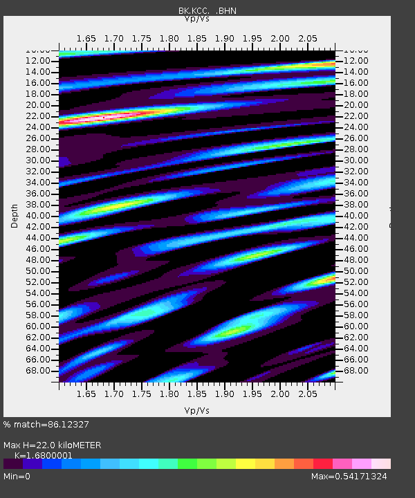
KCC Kaiser Creek, CA - Earthquake Result Viewer
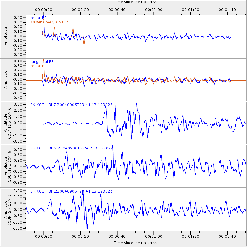
Earthquake location: Near S. Coast Of Honshu, Japan
Earthquake latitude/longitude: 33.2/137.2
Earthquake time(UTC): 2004/09/06 (250) 23:29:35 GMT
Earthquake Depth: 10 km
Earthquake Magnitude: 6.4 MB, 6.3 MS, 6.7 MW, 6.5 MW
Earthquake Catalog/Contributor: WHDF/NEIC
Network: BK Berkeley Digital Seismograph Network
Station: KCC Kaiser Creek, CA
Lat/Lon: 37.32 N/119.32 W
Elevation: 888 m
Distance: 80.0 deg
Az: 51.929 deg
Baz: 304.111 deg
Ray Param: 0.04857282
Estimated Moho Depth: 22.0 km
Estimated Crust Vp/Vs: 1.68
Assumed Crust Vp: 6.291 km/s
Estimated Crust Vs: 3.745 km/s
Estimated Crust Poisson's Ratio: 0.23
Radial Match: 86.12327 %
Radial Bump: 400
Transverse Match: 88.23963 %
Transverse Bump: 400
SOD ConfigId: 2459
Insert Time: 2010-03-05 19:34:16.416 +0000
GWidth: 2.5
Max Bumps: 400
Tol: 0.001

Signal To Noise

ChannelStoNSTALTA
BK:KCC: :BHN:20040906T23:41:13.12302Z1.28555861.2499224E-79.722796E-8
BK:KCC: :BHE:20040906T23:41:13.12302Z2.88926553.57985E-71.2390173E-7
BK:KCC: :BHZ:20040906T23:41:13.12302Z9.239421.1040156E-61.1948971E-7
Arrivals
Ps2.4 SECOND
PpPs9.1 SECOND
PsPs/PpSs12 SECOND