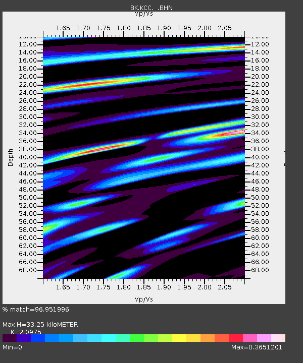
KCC Kaiser Creek, CA - Earthquake Result Viewer
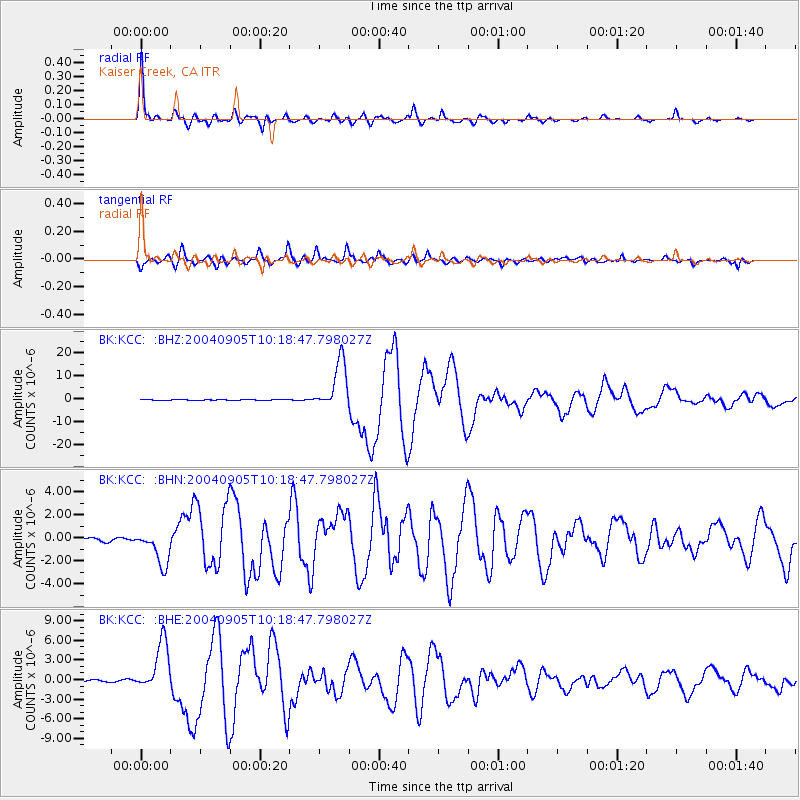
Earthquake location: Near S. Coast Of Western Honshu
Earthquake latitude/longitude: 33.1/136.6
Earthquake time(UTC): 2004/09/05 (249) 10:07:07 GMT
Earthquake Depth: 14 km
Earthquake Magnitude: 6.7 MB, 7.0 MS, 7.2 MW, 7.0 MW
Earthquake Catalog/Contributor: WHDF/NEIC
Network: BK Berkeley Digital Seismograph Network
Station: KCC Kaiser Creek, CA
Lat/Lon: 37.32 N/119.32 W
Elevation: 888 m
Distance: 80.5 deg
Az: 51.634 deg
Baz: 304.324 deg
Ray Param: 0.048234113
Estimated Moho Depth: 33.25 km
Estimated Crust Vp/Vs: 2.10
Assumed Crust Vp: 6.291 km/s
Estimated Crust Vs: 2.999 km/s
Estimated Crust Poisson's Ratio: 0.35
Radial Match: 96.951996 %
Radial Bump: 377
Transverse Match: 93.45417 %
Transverse Bump: 400
SOD ConfigId: 2459
Insert Time: 2010-03-05 19:34:17.795 +0000
GWidth: 2.5
Max Bumps: 400
Tol: 0.001

Signal To Noise

ChannelStoNSTALTA
BK:KCC: :BHN:20040905T10:18:47.798027Z12.5439021.4922987E-61.1896607E-7
BK:KCC: :BHE:20040905T10:18:47.798027Z30.4816843.8231633E-61.2542495E-7
BK:KCC: :BHZ:20040905T10:18:47.798027Z82.78251.0637743E-51.2850231E-7
Arrivals
Ps5.9 SECOND
PpPs16 SECOND
PsPs/PpSs22 SECOND