You are here: Home > Network List > TA - USArray Transportable Network (new EarthScope stations) Stations List
> Station TPFO Pinon Flats, CA, USA > Earthquake Result Viewer
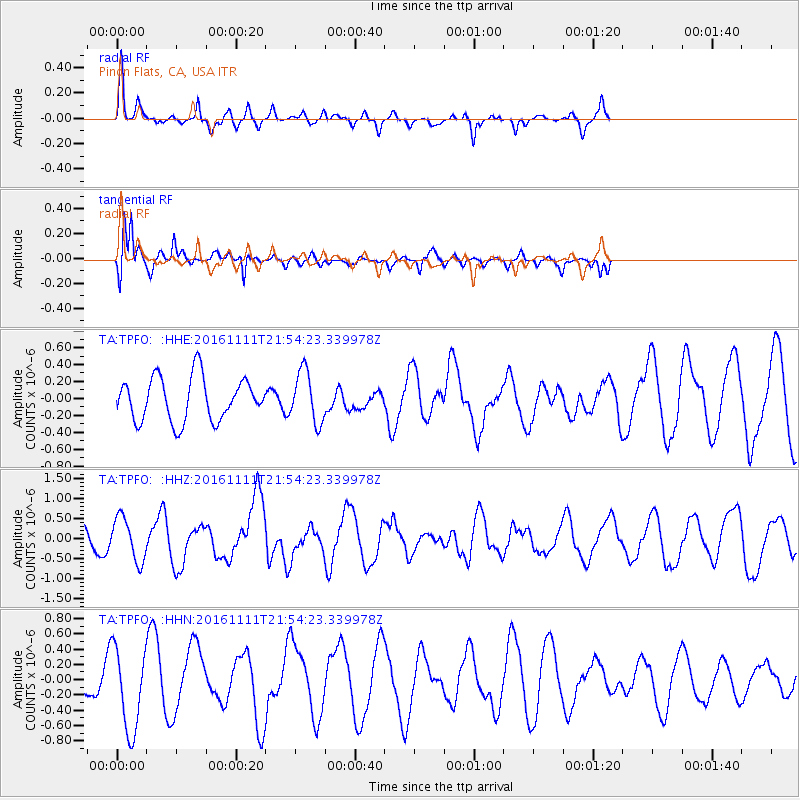
TPFO Pinon Flats, CA, USA - Earthquake Result Viewer
*The percent match for this event was below the threshold and hence no stack was calculated.
| Earthquake location: |
Near East Coast Of Honshu, Japan |
| Earthquake latitude/longitude: |
38.5/141.6 |
| Earthquake time(UTC): |
2016/11/11 (316) 21:42:59 GMT |
| Earthquake Depth: |
45 km |
| Earthquake Magnitude: |
6.2 MWB |
| Earthquake Catalog/Contributor: |
NEIC PDE/NEIC COMCAT |
|
| Network: |
TA USArray Transportable Network (new EarthScope stations) |
| Station: |
TPFO Pinon Flats, CA, USA |
| Lat/Lon: |
33.61 N/116.45 W |
| Elevation: |
1275 m |
|
| Distance: |
78.1 deg |
| Az: |
56.532 deg |
| Baz: |
308.345 deg |
| Ray Param: |
$rayparam |
*The percent match for this event was below the threshold and hence was not used in the summary stack. |
|
| Radial Match: |
48.849644 % |
| Radial Bump: |
280 |
| Transverse Match: |
83.58105 % |
| Transverse Bump: |
322 |
| SOD ConfigId: |
11737051 |
| Insert Time: |
2019-04-26 00:59:15.106 +0000 |
| GWidth: |
2.5 |
| Max Bumps: |
400 |
| Tol: |
0.001 |
|
Signal To Noise
| Channel | StoN | STA | LTA |
| TA:TPFO: :HHZ:20161111T21:54:23.339978Z | 2.0453067 | 5.438623E-7 | 2.6590746E-7 |
| TA:TPFO: :HHN:20161111T21:54:23.339978Z | 2.1815882 | 5.492849E-7 | 2.517821E-7 |
| TA:TPFO: :HHE:20161111T21:54:23.339978Z | 1.1632942 | 2.99891E-7 | 2.5779465E-7 |
| Arrivals |
| Ps | |
| PpPs | |
| PsPs/PpSs | |


