You are here: Home > Network List > US - United States National Seismic Network Stations List
> Station DUG Dugway, Tooele County, Utah, USA > Earthquake Result Viewer
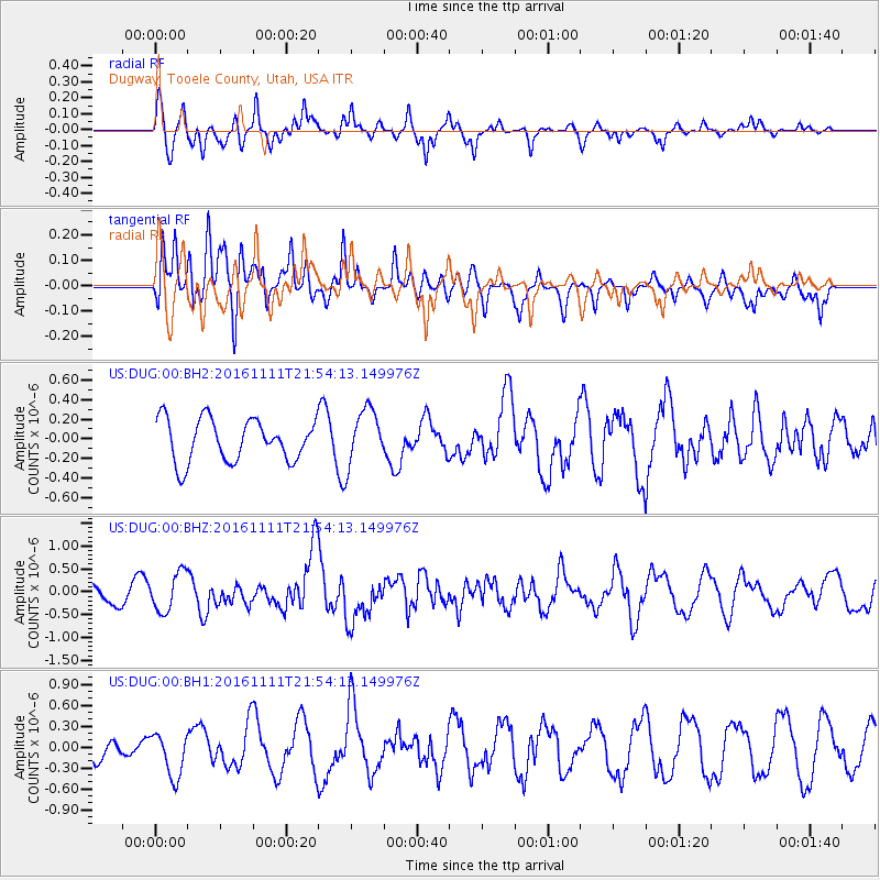
DUG Dugway, Tooele County, Utah, USA - Earthquake Result Viewer
*The percent match for this event was below the threshold and hence no stack was calculated.
| Earthquake location: |
Near East Coast Of Honshu, Japan |
| Earthquake latitude/longitude: |
38.5/141.6 |
| Earthquake time(UTC): |
2016/11/11 (316) 21:42:59 GMT |
| Earthquake Depth: |
45 km |
| Earthquake Magnitude: |
6.2 MWB |
| Earthquake Catalog/Contributor: |
NEIC PDE/NEIC COMCAT |
|
| Network: |
US United States National Seismic Network |
| Station: |
DUG Dugway, Tooele County, Utah, USA |
| Lat/Lon: |
40.19 N/112.81 W |
| Elevation: |
1477 m |
|
| Distance: |
76.3 deg |
| Az: |
49.397 deg |
| Baz: |
308.946 deg |
| Ray Param: |
$rayparam |
*The percent match for this event was below the threshold and hence was not used in the summary stack. |
|
| Radial Match: |
76.53282 % |
| Radial Bump: |
400 |
| Transverse Match: |
76.57563 % |
| Transverse Bump: |
400 |
| SOD ConfigId: |
11737051 |
| Insert Time: |
2019-04-26 00:59:39.697 +0000 |
| GWidth: |
2.5 |
| Max Bumps: |
400 |
| Tol: |
0.001 |
|
Signal To Noise
| Channel | StoN | STA | LTA |
| US:DUG:00:BHZ:20161111T21:54:13.149976Z | 1.1886076 | 4.2499894E-7 | 3.5756034E-7 |
| US:DUG:00:BH1:20161111T21:54:13.149976Z | 1.7270825 | 3.1410696E-7 | 1.8187143E-7 |
| US:DUG:00:BH2:20161111T21:54:13.149976Z | 1.4985673 | 3.206175E-7 | 2.1394935E-7 |
| Arrivals |
| Ps | |
| PpPs | |
| PsPs/PpSs | |


