You are here: Home > Network List > US - United States National Seismic Network Stations List
> Station MIAR Mount Ida, Arkansas, USA > Earthquake Result Viewer
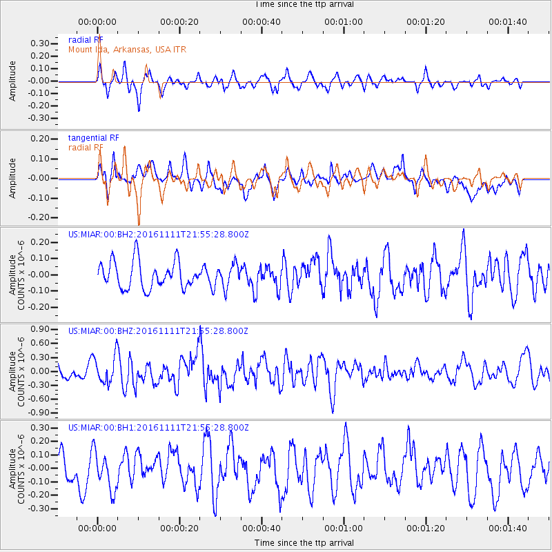
MIAR Mount Ida, Arkansas, USA - Earthquake Result Viewer
*The percent match for this event was below the threshold and hence no stack was calculated.
| Earthquake location: |
Near East Coast Of Honshu, Japan |
| Earthquake latitude/longitude: |
38.5/141.6 |
| Earthquake time(UTC): |
2016/11/11 (316) 21:42:59 GMT |
| Earthquake Depth: |
45 km |
| Earthquake Magnitude: |
6.2 MWB |
| Earthquake Catalog/Contributor: |
NEIC PDE/NEIC COMCAT |
|
| Network: |
US United States National Seismic Network |
| Station: |
MIAR Mount Ida, Arkansas, USA |
| Lat/Lon: |
34.55 N/93.58 W |
| Elevation: |
207 m |
|
| Distance: |
91.2 deg |
| Az: |
42.644 deg |
| Baz: |
319.913 deg |
| Ray Param: |
$rayparam |
*The percent match for this event was below the threshold and hence was not used in the summary stack. |
|
| Radial Match: |
53.453434 % |
| Radial Bump: |
393 |
| Transverse Match: |
60.392212 % |
| Transverse Bump: |
400 |
| SOD ConfigId: |
11737051 |
| Insert Time: |
2019-04-26 00:59:44.581 +0000 |
| GWidth: |
2.5 |
| Max Bumps: |
400 |
| Tol: |
0.001 |
|
Signal To Noise
| Channel | StoN | STA | LTA |
| US:MIAR:00:BHZ:20161111T21:55:28.800Z | 1.3703945 | 3.048612E-7 | 2.2246238E-7 |
| US:MIAR:00:BH1:20161111T21:55:28.800Z | 1.3181021 | 1.3887617E-7 | 1.0536071E-7 |
| US:MIAR:00:BH2:20161111T21:55:28.800Z | 0.8762023 | 7.332008E-8 | 8.3679396E-8 |
| Arrivals |
| Ps | |
| PpPs | |
| PsPs/PpSs | |


