You are here: Home > Network List > CI - Caltech Regional Seismic Network Stations List
> Station SMM Simmler, CA, USA > Earthquake Result Viewer
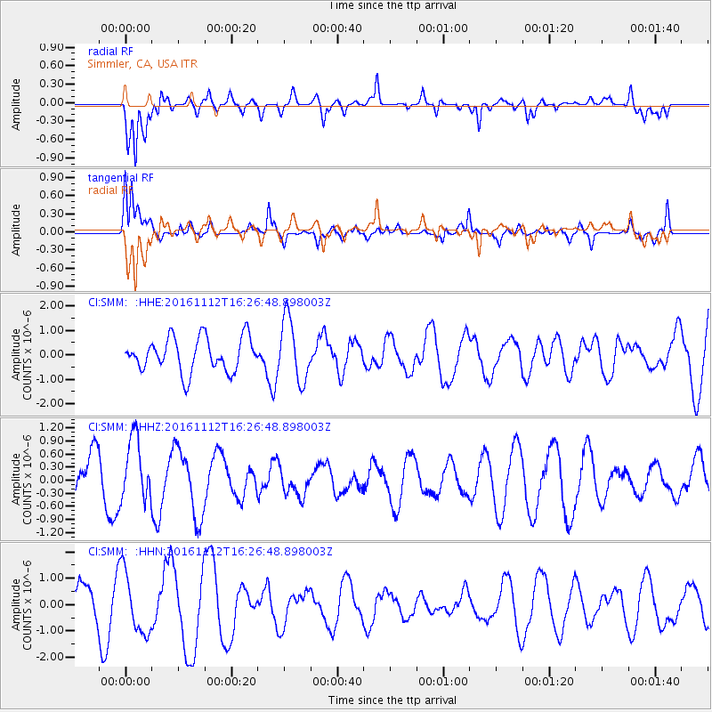
SMM Simmler, CA, USA - Earthquake Result Viewer
*The percent match for this event was below the threshold and hence no stack was calculated.
| Earthquake location: |
South Of Fiji Islands |
| Earthquake latitude/longitude: |
-25.0/178.7 |
| Earthquake time(UTC): |
2016/11/12 (317) 16:15:51 GMT |
| Earthquake Depth: |
565 km |
| Earthquake Magnitude: |
5.5 MB |
| Earthquake Catalog/Contributor: |
NEIC PDE/NEIC COMCAT |
|
| Network: |
CI Caltech Regional Seismic Network |
| Station: |
SMM Simmler, CA, USA |
| Lat/Lon: |
35.31 N/120.00 W |
| Elevation: |
599 m |
|
| Distance: |
83.4 deg |
| Az: |
46.253 deg |
| Baz: |
233.297 deg |
| Ray Param: |
$rayparam |
*The percent match for this event was below the threshold and hence was not used in the summary stack. |
|
| Radial Match: |
66.11935 % |
| Radial Bump: |
400 |
| Transverse Match: |
71.63654 % |
| Transverse Bump: |
381 |
| SOD ConfigId: |
11737051 |
| Insert Time: |
2019-04-26 01:03:49.674 +0000 |
| GWidth: |
2.5 |
| Max Bumps: |
400 |
| Tol: |
0.001 |
|
Signal To Noise
| Channel | StoN | STA | LTA |
| CI:SMM: :HHZ:20161112T16:26:48.898003Z | 1.2306094 | 7.199422E-7 | 5.85029E-7 |
| CI:SMM: :HHN:20161112T16:26:48.898003Z | 1.6952004 | 1.1633954E-6 | 6.8628776E-7 |
| CI:SMM: :HHE:20161112T16:26:48.898003Z | 1.8548716 | 1.2790961E-6 | 6.895874E-7 |
| Arrivals |
| Ps | |
| PpPs | |
| PsPs/PpSs | |


