You are here: Home > Network List > GS - US Geological Survey Networks Stations List
> Station DEC05 Decatur Surface Seismic Site, Decatur, IL, USA > Earthquake Result Viewer
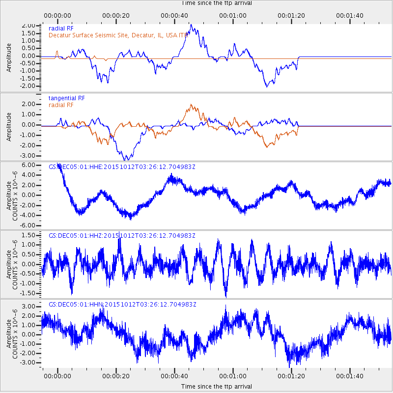
DEC05 Decatur Surface Seismic Site, Decatur, IL, USA - Earthquake Result Viewer
*The percent match for this event was below the threshold and hence no stack was calculated.
| Earthquake location: |
Near Coast Of Central Chile |
| Earthquake latitude/longitude: |
-31.2/-71.8 |
| Earthquake time(UTC): |
2015/10/12 (285) 03:15:19 GMT |
| Earthquake Depth: |
21 km |
| Earthquake Magnitude: |
5.6 MWW, 5.3 MWR, 5.5 MWB |
| Earthquake Catalog/Contributor: |
NEIC PDE/NEIC COMCAT |
|
| Network: |
GS US Geological Survey Networks |
| Station: |
DEC05 Decatur Surface Seismic Site, Decatur, IL, USA |
| Lat/Lon: |
39.87 N/88.87 W |
| Elevation: |
216 m |
|
| Distance: |
72.4 deg |
| Az: |
346.315 deg |
| Baz: |
164.724 deg |
| Ray Param: |
$rayparam |
*The percent match for this event was below the threshold and hence was not used in the summary stack. |
|
| Radial Match: |
33.85873 % |
| Radial Bump: |
400 |
| Transverse Match: |
25.678268 % |
| Transverse Bump: |
400 |
| SOD ConfigId: |
1259291 |
| Insert Time: |
2015-10-29 05:24:48.986 +0000 |
| GWidth: |
2.5 |
| Max Bumps: |
400 |
| Tol: |
0.001 |
|
Signal To Noise
| Channel | StoN | STA | LTA |
| GS:DEC05:01:HHZ:20151012T03:26:12.704983Z | 1.1306851 | 4.4284855E-7 | 3.916639E-7 |
| GS:DEC05:01:HHN:20151012T03:26:12.704983Z | 0.9686948 | 1.8948598E-6 | 1.9560957E-6 |
| GS:DEC05:01:HHE:20151012T03:26:12.704983Z | 0.39687544 | 9.90998E-7 | 2.4970002E-6 |
| Arrivals |
| Ps | |
| PpPs | |
| PsPs/PpSs | |


