You are here: Home > Network List > TA - USArray Transportable Network (new EarthScope stations) Stations List
> Station MSTX Muleshoe, TX, USA > Earthquake Result Viewer
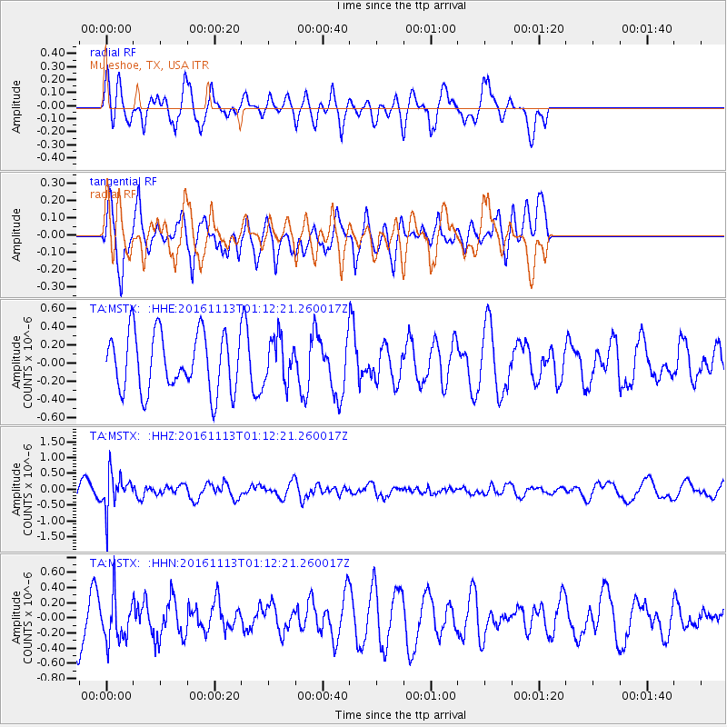
MSTX Muleshoe, TX, USA - Earthquake Result Viewer
*The percent match for this event was below the threshold and hence no stack was calculated.
| Earthquake location: |
La Rioja Province, Argentina |
| Earthquake latitude/longitude: |
-28.1/-67.3 |
| Earthquake time(UTC): |
2016/11/13 (318) 01:01:51 GMT |
| Earthquake Depth: |
121 km |
| Earthquake Magnitude: |
5.7 MB |
| Earthquake Catalog/Contributor: |
NEIC PDE/NEIC COMCAT |
|
| Network: |
TA USArray Transportable Network (new EarthScope stations) |
| Station: |
MSTX Muleshoe, TX, USA |
| Lat/Lon: |
33.97 N/102.77 W |
| Elevation: |
1167 m |
|
| Distance: |
70.3 deg |
| Az: |
329.201 deg |
| Baz: |
147.024 deg |
| Ray Param: |
$rayparam |
*The percent match for this event was below the threshold and hence was not used in the summary stack. |
|
| Radial Match: |
65.973366 % |
| Radial Bump: |
400 |
| Transverse Match: |
56.10243 % |
| Transverse Bump: |
400 |
| SOD ConfigId: |
11737051 |
| Insert Time: |
2019-04-26 01:22:39.071 +0000 |
| GWidth: |
2.5 |
| Max Bumps: |
400 |
| Tol: |
0.001 |
|
Signal To Noise
| Channel | StoN | STA | LTA |
| TA:MSTX: :HHZ:20161113T01:12:21.260017Z | 2.4146647 | 5.8118417E-7 | 2.406894E-7 |
| TA:MSTX: :HHN:20161113T01:12:21.260017Z | 1.138827 | 2.9677017E-7 | 2.6059283E-7 |
| TA:MSTX: :HHE:20161113T01:12:21.260017Z | 0.7634274 | 2.4317617E-7 | 3.1853216E-7 |
| Arrivals |
| Ps | |
| PpPs | |
| PsPs/PpSs | |


