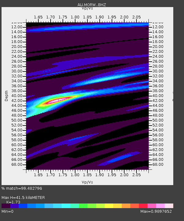
MORW Morawa, Western Australia - Earthquake Result Viewer

Earthquake location: South Island, New Zealand
Earthquake latitude/longitude: -42.7/173.1
Earthquake time(UTC): 2016/11/13 (318) 11:02:59 GMT
Earthquake Depth: 22 km
Earthquake Magnitude: 7.8 MWW, 7.2 MWB, 7.4 MI, 7.8 MWC
Earthquake Catalog/Contributor: NEIC PDE/NEIC COMCAT
Network: AU Australian Seismological Centre
Station: MORW Morawa, Western Australia
Lat/Lon: 29.07 S/116.04 E
Elevation: 296 m
Distance: 47.3 deg
Az: 267.344 deg
Baz: 122.771 deg
Ray Param: 0.07003378
Estimated Moho Depth: 41.5 km
Estimated Crust Vp/Vs: 1.73
Assumed Crust Vp: 6.459 km/s
Estimated Crust Vs: 3.734 km/s
Estimated Crust Poisson's Ratio: 0.25
Radial Match: 99.482796 %
Radial Bump: 186
Transverse Match: 94.57534 %
Transverse Bump: 400
SOD ConfigId: 11737051
Insert Time: 2019-04-26 01:25:22.921 +0000
GWidth: 2.5
Max Bumps: 400
Tol: 0.001

Signal To Noise

ChannelStoNSTALTA
AU:MORW: :BHZ:20161113T11:11:00.193993Z4.5120471.717105E-63.805601E-7
AU:MORW: :BHN:20161113T11:11:00.193993Z1.87135544.89979E-72.6183108E-7
AU:MORW: :BHE:20161113T11:11:00.193993Z6.05240351.026077E-61.6953216E-7
Arrivals
Ps5.0 SECOND
PpPs16 SECOND
PsPs/PpSs21 SECOND