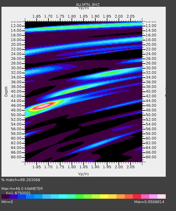
MTN Manton Dam, Northern Territory - Earthquake Result Viewer

Earthquake location: South Island, New Zealand
Earthquake latitude/longitude: -42.7/173.1
Earthquake time(UTC): 2016/11/13 (318) 11:02:59 GMT
Earthquake Depth: 22 km
Earthquake Magnitude: 7.8 MWW, 7.2 MWB, 7.4 MI, 7.8 MWC
Earthquake Catalog/Contributor: NEIC PDE/NEIC COMCAT
Network: AU Australian Seismological Centre
Station: MTN Manton Dam, Northern Territory
Lat/Lon: 12.84 S/131.13 E
Elevation: 137 m
Distance: 46.8 deg
Az: 296.696 deg
Baz: 137.545 deg
Ray Param: 0.07035195
Estimated Moho Depth: 46.0 km
Estimated Crust Vp/Vs: 1.68
Assumed Crust Vp: 6.61 km/s
Estimated Crust Vs: 3.946 km/s
Estimated Crust Poisson's Ratio: 0.22
Radial Match: 99.283066 %
Radial Bump: 253
Transverse Match: 86.6374 %
Transverse Bump: 400
SOD ConfigId: 11737051
Insert Time: 2019-04-26 01:25:23.180 +0000
GWidth: 2.5
Max Bumps: 400
Tol: 0.001

Signal To Noise

ChannelStoNSTALTA
AU:MTN: :BHZ:20161113T11:10:56.494011Z5.5359781.0576664E-61.9105322E-7
AU:MTN: :BHN:20161113T11:10:56.494011Z3.3556685.7622685E-71.7171747E-7
AU:MTN: :BHE:20161113T11:10:56.494011Z2.9330635.397418E-71.8401985E-7
Arrivals
Ps5.0 SECOND
PpPs17 SECOND
PsPs/PpSs22 SECOND