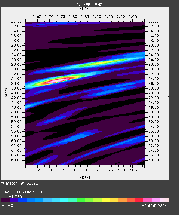
MEEK Meekatharra, Western Australia - Earthquake Result Viewer

Earthquake location: South Island, New Zealand
Earthquake latitude/longitude: -42.7/173.1
Earthquake time(UTC): 2016/11/13 (318) 11:02:59 GMT
Earthquake Depth: 22 km
Earthquake Magnitude: 7.8 MWW, 7.2 MWB, 7.4 MI, 7.8 MWC
Earthquake Catalog/Contributor: NEIC PDE/NEIC COMCAT
Network: AU Australian Seismological Centre
Station: MEEK Meekatharra, Western Australia
Lat/Lon: 26.64 S/118.61 E
Elevation: 530 m
Distance: 46.8 deg
Az: 271.824 deg
Baz: 124.627 deg
Ray Param: 0.07040286
Estimated Moho Depth: 34.5 km
Estimated Crust Vp/Vs: 1.74
Assumed Crust Vp: 6.459 km/s
Estimated Crust Vs: 3.723 km/s
Estimated Crust Poisson's Ratio: 0.25
Radial Match: 99.52291 %
Radial Bump: 249
Transverse Match: 93.04771 %
Transverse Bump: 400
SOD ConfigId: 11737051
Insert Time: 2019-04-26 01:25:23.675 +0000
GWidth: 2.5
Max Bumps: 400
Tol: 0.001

Signal To Noise

ChannelStoNSTALTA
AU:MEEK: :BHZ:20161113T11:10:55.894005Z6.1604911.5056409E-62.4440274E-7
AU:MEEK: :BHN:20161113T11:10:55.894005Z1.67026154.8051794E-72.8769026E-7
AU:MEEK: :BHE:20161113T11:10:55.894005Z4.2622741.0457317E-62.4534594E-7
Arrivals
Ps4.2 SECOND
PpPs14 SECOND
PsPs/PpSs18 SECOND