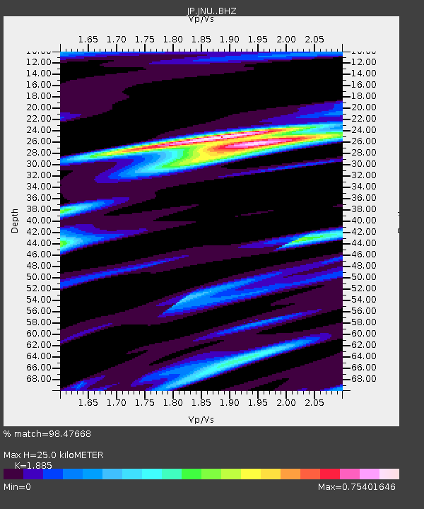
JNU Oita Nakatsue - Earthquake Result Viewer

Earthquake location: South Island, New Zealand
Earthquake latitude/longitude: -42.7/173.1
Earthquake time(UTC): 2016/11/13 (318) 11:02:59 GMT
Earthquake Depth: 22 km
Earthquake Magnitude: 7.8 MWW, 7.2 MWB, 7.4 MI, 7.8 MWC
Earthquake Catalog/Contributor: NEIC PDE/NEIC COMCAT
Network: JP Japan Meteorological Agency Seismic Network
Station: JNU Oita Nakatsue
Lat/Lon: 33.12 N/130.88 E
Elevation: 540 m
Distance: 84.8 deg
Az: 325.538 deg
Baz: 150.205 deg
Ray Param: 0.04519554
Estimated Moho Depth: 25.0 km
Estimated Crust Vp/Vs: 1.88
Assumed Crust Vp: 6.468 km/s
Estimated Crust Vs: 3.431 km/s
Estimated Crust Poisson's Ratio: 0.30
Radial Match: 98.47668 %
Radial Bump: 400
Transverse Match: 93.273445 %
Transverse Bump: 400
SOD ConfigId: 11737051
Insert Time: 2019-04-26 01:26:21.486 +0000
GWidth: 2.5
Max Bumps: 400
Tol: 0.001

Signal To Noise

ChannelStoNSTALTA
JP:JNU: :BHZ:20161113T11:15:00.29998Z6.1811775.3927045E-78.7243976E-8
JP:JNU: :BHN:20161113T11:15:00.29998Z1.38587891.4729716E-71.0628429E-7
JP:JNU: :BHE:20161113T11:15:00.29998Z2.06038711.9395489E-79.4135174E-8
Arrivals
Ps3.5 SECOND
PpPs11 SECOND
PsPs/PpSs14 SECOND