WAWA WAWA - Earthquake Result Viewer
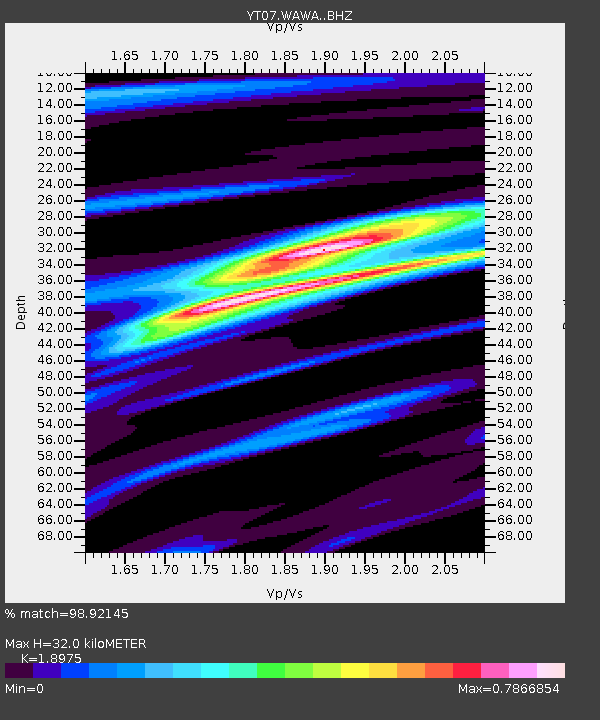
Earthquake location: South Island, New Zealand
Earthquake latitude/longitude: -42.7/173.1
Earthquake time(UTC): 2016/11/13 (318) 11:02:59 GMT
Earthquake Depth: 22 km
Earthquake Magnitude: 7.8 MWW, 7.2 MWB, 7.4 MI, 7.8 MWC
Earthquake Catalog/Contributor: NEIC PDE/NEIC COMCAT
Network: YT POLENET
Station: WAWA WAWA
Lat/Lon: 81.58 S/28.42 W
Elevation: 1202 m
Distance: 55.4 deg
Az: 176.24 deg
Baz: 199.135 deg
Ray Param: 0.0647751
Estimated Moho Depth: 32.0 km
Estimated Crust Vp/Vs: 1.90
Assumed Crust Vp: 6.424 km/s
Estimated Crust Vs: 3.386 km/s
Estimated Crust Poisson's Ratio: 0.31
Radial Match: 98.92145 %
Radial Bump: 328
Transverse Match: 94.45941 %
Transverse Bump: 400
SOD ConfigId: 11737051
Insert Time: 2019-04-26 01:27:26.077 +0000
GWidth: 2.5
Max Bumps: 400
Tol: 0.001

Signal To Noise

ChannelStoNSTALTA
YT:WAWA: :BHZ:20161113T11:12:00.775017Z13.3155432.0663501E-61.5518332E-7
YT:WAWA: :BHN:20161113T11:12:00.775017Z9.8553149.1564397E-79.290866E-8
YT:WAWA: :BHE:20161113T11:12:00.775017Z3.40824773.257673E-79.558205E-8
Arrivals
Ps4.7 SECOND
PpPs14 SECOND
PsPs/PpSs18 SECOND