You are here: Home > Network List > YT07 - POLENET Stations List
> Station MA07 Polenet mini-array MA07 > Earthquake Result Viewer
MA07 Polenet mini-array MA07 - Earthquake Result Viewer
| Earthquake location: |
South Island, New Zealand |
| Earthquake latitude/longitude: |
-42.2/173.4 |
| Earthquake time(UTC): |
2016/11/13 (318) 11:19:34 GMT |
| Earthquake Depth: |
10 km |
| Earthquake Magnitude: |
5.5 MB |
| Earthquake Catalog/Contributor: |
NEIC PDE/NEIC COMCAT |
|
| Network: |
YT POLENET |
| Station: |
MA07 Polenet mini-array MA07 |
| Lat/Lon: |
78.25 S/93.50 W |
| Elevation: |
1648 m |
|
| Distance: |
49.7 deg |
| Az: |
164.429 deg |
| Baz: |
256.643 deg |
| Ray Param: |
0.06854619 |
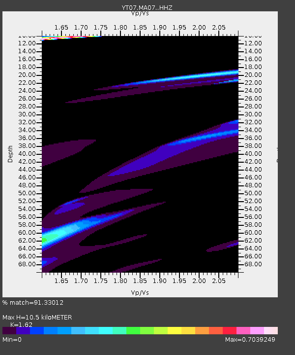
| Estimated Moho Depth: |
10.5 km |
| Estimated Crust Vp/Vs: |
1.62 |
| Assumed Crust Vp: |
6.095 km/s |
| Estimated Crust Vs: |
3.762 km/s |
| Estimated Crust Poisson's Ratio: |
0.19 |
|
| Radial Match: |
91.33012 % |
| Radial Bump: |
400 |
| Transverse Match: |
40.953888 % |
| Transverse Bump: |
241 |
| SOD ConfigId: |
11737051 |
| Insert Time: |
2019-04-26 01:32:30.534 +0000 |
| GWidth: |
2.5 |
| Max Bumps: |
400 |
| Tol: |
0.001 |
|

Signal To Noise
| Channel | StoN | STA | LTA |
| YT:MA07: :HHZ:20161113T11:27:55.839005Z | 1.405837 | 1.2111768E-4 | 8.615343E-5 |
| YT:MA07: :HHN:20161113T11:27:55.839005Z | 0.8794116 | 7.462676E-5 | 8.485989E-5 |
| YT:MA07: :HHE:20161113T11:27:55.839005Z | 1.4391538 | 1.6790087E-4 | 1.16666386E-4 |
| Arrivals |
| Ps | 1.1 SECOND |
| PpPs | 4.3 SECOND |
| PsPs/PpSs | 5.4 SECOND |


