You are here: Home > Network List > AV - Alaska Volcano Observatory Stations List
> Station MAPS Pakushin Southeast, Makushin Volcano, Alaska > Earthquake Result Viewer
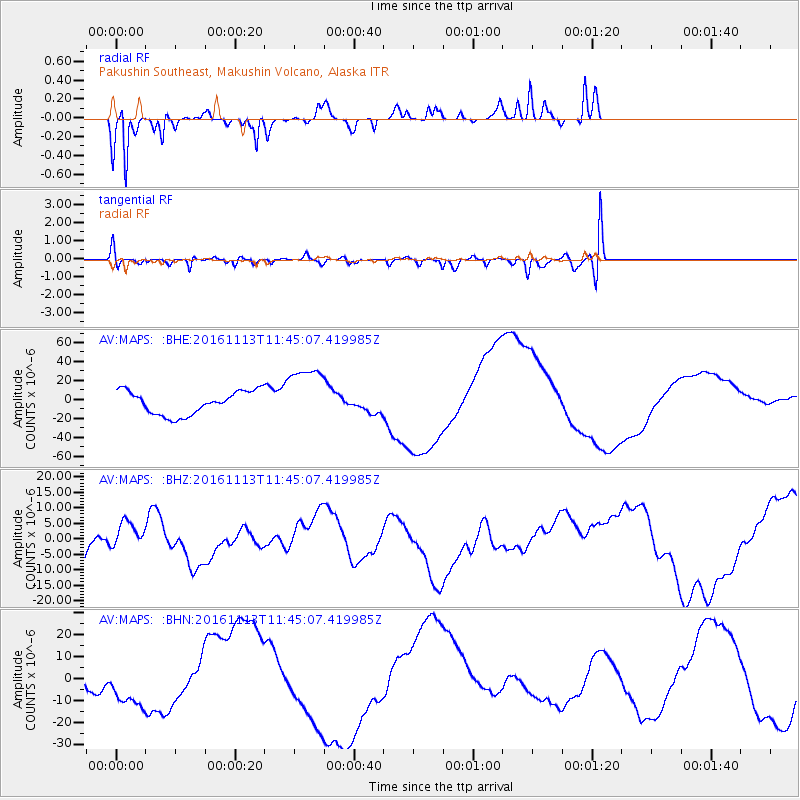
MAPS Pakushin Southeast, Makushin Volcano, Alaska - Earthquake Result Viewer
*The percent match for this event was below the threshold and hence no stack was calculated.
| Earthquake location: |
South Island, New Zealand |
| Earthquake latitude/longitude: |
-42.3/173.6 |
| Earthquake time(UTC): |
2016/11/13 (318) 11:32:07 GMT |
| Earthquake Depth: |
10 km |
| Earthquake Magnitude: |
6.5 MWW, 7.9 MI |
| Earthquake Catalog/Contributor: |
NEIC PDE/NEIC COMCAT |
|
| Network: |
AV Alaska Volcano Observatory |
| Station: |
MAPS Pakushin Southeast, Makushin Volcano, Alaska |
| Lat/Lon: |
53.81 N/166.94 W |
| Elevation: |
333 m |
|
| Distance: |
97.1 deg |
| Az: |
11.468 deg |
| Baz: |
194.412 deg |
| Ray Param: |
$rayparam |
*The percent match for this event was below the threshold and hence was not used in the summary stack. |
|
| Radial Match: |
64.61885 % |
| Radial Bump: |
257 |
| Transverse Match: |
37.206604 % |
| Transverse Bump: |
384 |
| SOD ConfigId: |
11737051 |
| Insert Time: |
2019-04-26 01:33:42.230 +0000 |
| GWidth: |
2.5 |
| Max Bumps: |
400 |
| Tol: |
0.001 |
|
Signal To Noise
| Channel | StoN | STA | LTA |
| AV:MAPS: :BHZ:20161113T11:45:07.419985Z | 1.1924574 | 4.659891E-6 | 3.907805E-6 |
| AV:MAPS: :BHN:20161113T11:45:07.419985Z | 1.2310512 | 1.1169276E-5 | 9.072958E-6 |
| AV:MAPS: :BHE:20161113T11:45:07.419985Z | 2.4818213 | 3.1221778E-5 | 1.2580187E-5 |
| Arrivals |
| Ps | |
| PpPs | |
| PsPs/PpSs | |


