You are here: Home > Network List > AV - Alaska Volcano Observatory Stations List
> Station MAPS Pakushin Southeast, Makushin Volcano, Alaska > Earthquake Result Viewer
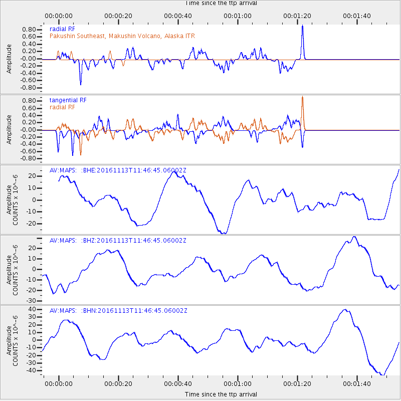
MAPS Pakushin Southeast, Makushin Volcano, Alaska - Earthquake Result Viewer
*The percent match for this event was below the threshold and hence no stack was calculated.
| Earthquake location: |
Off E. Coast Of S. Island, N.Z. |
| Earthquake latitude/longitude: |
-42.1/174.3 |
| Earthquake time(UTC): |
2016/11/13 (318) 11:33:45 GMT |
| Earthquake Depth: |
10 km |
| Earthquake Magnitude: |
5.8 MB |
| Earthquake Catalog/Contributor: |
NEIC PDE/NEIC COMCAT |
|
| Network: |
AV Alaska Volcano Observatory |
| Station: |
MAPS Pakushin Southeast, Makushin Volcano, Alaska |
| Lat/Lon: |
53.81 N/166.94 W |
| Elevation: |
333 m |
|
| Distance: |
96.8 deg |
| Az: |
11.073 deg |
| Baz: |
193.957 deg |
| Ray Param: |
$rayparam |
*The percent match for this event was below the threshold and hence was not used in the summary stack. |
|
| Radial Match: |
73.067116 % |
| Radial Bump: |
358 |
| Transverse Match: |
67.97832 % |
| Transverse Bump: |
340 |
| SOD ConfigId: |
11737051 |
| Insert Time: |
2019-04-26 01:36:07.197 +0000 |
| GWidth: |
2.5 |
| Max Bumps: |
400 |
| Tol: |
0.001 |
|
Signal To Noise
| Channel | StoN | STA | LTA |
| AV:MAPS: :BHZ:20161113T11:46:45.06002Z | 3.96369 | 2.0148318E-5 | 5.0832227E-6 |
| AV:MAPS: :BHN:20161113T11:46:45.06002Z | 2.8486753 | 2.7153199E-5 | 9.531869E-6 |
| AV:MAPS: :BHE:20161113T11:46:45.06002Z | 1.6587657 | 1.6120188E-5 | 9.718183E-6 |
| Arrivals |
| Ps | |
| PpPs | |
| PsPs/PpSs | |


