You are here: Home > Network List > BK - Berkeley Digital Seismograph Network Stations List
> Station MNRC McLaughlin Mine, CA > Earthquake Result Viewer
MNRC McLaughlin Mine, CA - Earthquake Result Viewer
| Earthquake location: |
Galapagos Islands, Ecuador |
| Earthquake latitude/longitude: |
-0.9/-91.0 |
| Earthquake time(UTC): |
2005/10/22 (295) 20:34:41 GMT |
| Earthquake Depth: |
10 km |
| Earthquake Magnitude: |
4.9 MB, 5.5 MW |
| Earthquake Catalog/Contributor: |
WHDF/NEIC |
|
| Network: |
BK Berkeley Digital Seismograph Network |
| Station: |
MNRC McLaughlin Mine, CA |
| Lat/Lon: |
38.88 N/122.44 W |
| Elevation: |
710 m |
|
| Distance: |
49.0 deg |
| Az: |
327.294 deg |
| Baz: |
136.197 deg |
| Ray Param: |
0.06899381 |
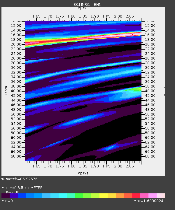
| Estimated Moho Depth: |
15.5 km |
| Estimated Crust Vp/Vs: |
2.06 |
| Assumed Crust Vp: |
6.472 km/s |
| Estimated Crust Vs: |
3.142 km/s |
| Estimated Crust Poisson's Ratio: |
0.35 |
|
| Radial Match: |
85.92576 % |
| Radial Bump: |
400 |
| Transverse Match: |
70.762825 % |
| Transverse Bump: |
400 |
| SOD ConfigId: |
124340 |
| Insert Time: |
2010-03-05 19:37:40.298 +0000 |
| GWidth: |
2.5 |
| Max Bumps: |
400 |
| Tol: |
0.001 |
|

Signal To Noise
| Channel | StoN | STA | LTA |
| BK:MNRC: :BHN:20051022T20:42:57.59399Z | 0.4188242 | 3.8902408E-7 | 9.288481E-7 |
| BK:MNRC: :BHE:20051022T20:42:57.59399Z | 0.619214 | 6.793233E-7 | 1.0970736E-6 |
| BK:MNRC: :BHZ:20051022T20:42:57.59399Z | 1.7250484 | 1.7060404E-6 | 9.889811E-7 |
| Arrivals |
| Ps | 2.7 SECOND |
| PpPs | 7.0 SECOND |
| PsPs/PpSs | 9.6 SECOND |


