You are here: Home > Network List > BK - Berkeley Digital Seismograph Network Stations List
> Station MNRC McLaughlin Mine, CA > Earthquake Result Viewer
MNRC McLaughlin Mine, CA - Earthquake Result Viewer
| Earthquake location: |
Rat Islands, Aleutian Islands |
| Earthquake latitude/longitude: |
51.2/179.4 |
| Earthquake time(UTC): |
2005/06/14 (165) 17:10:16 GMT |
| Earthquake Depth: |
51 km |
| Earthquake Magnitude: |
6.0 MB, 6.8 MW, 6.6 MW |
| Earthquake Catalog/Contributor: |
WHDF/NEIC |
|
| Network: |
BK Berkeley Digital Seismograph Network |
| Station: |
MNRC McLaughlin Mine, CA |
| Lat/Lon: |
38.88 N/122.44 W |
| Elevation: |
710 m |
|
| Distance: |
41.8 deg |
| Az: |
83.739 deg |
| Baz: |
306.803 deg |
| Ray Param: |
0.07339606 |
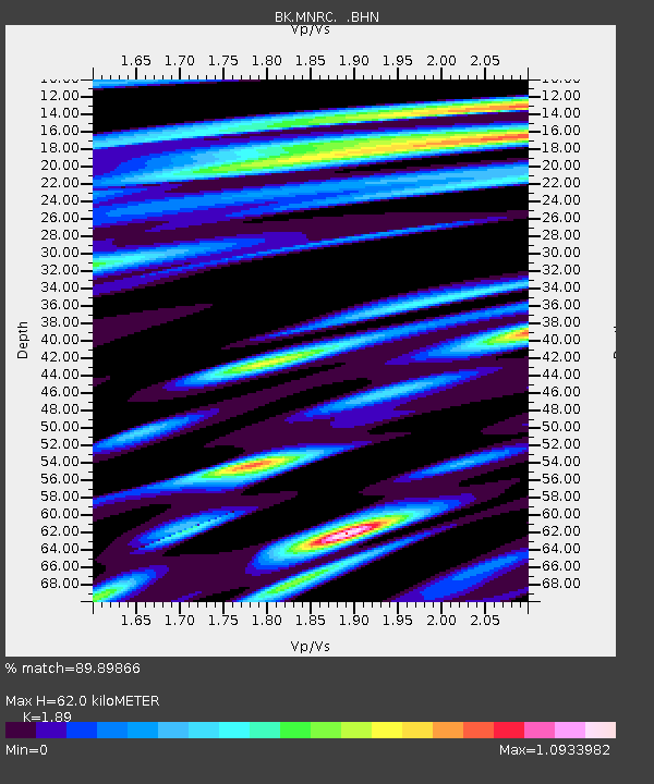
| Estimated Moho Depth: |
62.0 km |
| Estimated Crust Vp/Vs: |
1.89 |
| Assumed Crust Vp: |
6.472 km/s |
| Estimated Crust Vs: |
3.424 km/s |
| Estimated Crust Poisson's Ratio: |
0.31 |
|
| Radial Match: |
89.89866 % |
| Radial Bump: |
400 |
| Transverse Match: |
78.69366 % |
| Transverse Bump: |
400 |
| SOD ConfigId: |
124340 |
| Insert Time: |
2010-03-05 19:37:41.481 +0000 |
| GWidth: |
2.5 |
| Max Bumps: |
400 |
| Tol: |
0.001 |
|

Signal To Noise
| Channel | StoN | STA | LTA |
| BK:MNRC: :BHN:20050614T17:17:31.09401Z | 1.9008694 | 1.0849132E-6 | 5.707457E-7 |
| BK:MNRC: :BHE:20050614T17:17:31.09401Z | 1.4344165 | 6.8863136E-7 | 4.800777E-7 |
| BK:MNRC: :BHZ:20050614T17:17:31.09401Z | 5.1268444 | 1.9353804E-6 | 3.7749933E-7 |
| Arrivals |
| Ps | 9.1 SECOND |
| PpPs | 26 SECOND |
| PsPs/PpSs | 35 SECOND |


