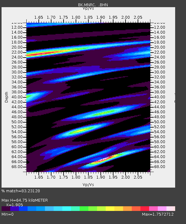
MNRC McLaughlin Mine, CA - Earthquake Result Viewer
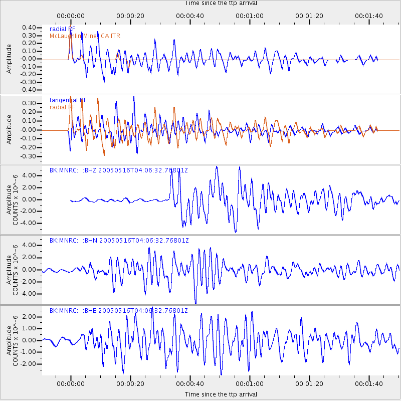
Earthquake location: South Of Kermadec Islands
Earthquake latitude/longitude: -32.6/-179.4
Earthquake time(UTC): 2005/05/16 (136) 03:54:14 GMT
Earthquake Depth: 34 km
Earthquake Magnitude: 6.2 MB, 6.4 MS, 6.6 MW, 6.6 MW
Earthquake Catalog/Contributor: WHDF/NEIC
Network: BK Berkeley Digital Seismograph Network
Station: MNRC McLaughlin Mine, CA
Lat/Lon: 38.88 N/122.44 W
Elevation: 710 m
Distance: 88.6 deg
Az: 40.854 deg
Baz: 225.031 deg
Ray Param: 0.04243089
Estimated Moho Depth: 64.75 km
Estimated Crust Vp/Vs: 1.90
Assumed Crust Vp: 6.472 km/s
Estimated Crust Vs: 3.397 km/s
Estimated Crust Poisson's Ratio: 0.31
Radial Match: 83.23128 %
Radial Bump: 400
Transverse Match: 80.75621 %
Transverse Bump: 400
SOD ConfigId: 124340
Insert Time: 2010-03-05 19:37:43.214 +0000
GWidth: 2.5
Max Bumps: 400
Tol: 0.001

Signal To Noise

ChannelStoNSTALTA
BK:MNRC: :BHN:20050516T04:06:32.76801Z1.57928263.258776E-72.0634533E-7
BK:MNRC: :BHE:20050516T04:06:32.76801Z2.356122.906392E-71.2335501E-7
BK:MNRC: :BHZ:20050516T04:06:32.76801Z7.9702531.6517731E-62.0724224E-7
Arrivals
Ps9.2 SECOND
PpPs28 SECOND
PsPs/PpSs38 SECOND