You are here: Home > Network List > BK - Berkeley Digital Seismograph Network Stations List
> Station MNRC McLaughlin Mine, CA > Earthquake Result Viewer
MNRC McLaughlin Mine, CA - Earthquake Result Viewer
| Earthquake location: |
New Britain Region, P.N.G. |
| Earthquake latitude/longitude: |
-6.3/150.7 |
| Earthquake time(UTC): |
2005/02/23 (054) 12:12:43 GMT |
| Earthquake Depth: |
10 km |
| Earthquake Magnitude: |
5.1 MB, 5.7 MW |
| Earthquake Catalog/Contributor: |
WHDF/NEIC |
|
| Network: |
BK Berkeley Digital Seismograph Network |
| Station: |
MNRC McLaughlin Mine, CA |
| Lat/Lon: |
38.88 N/122.44 W |
| Elevation: |
710 m |
|
| Distance: |
91.5 deg |
| Az: |
51.225 deg |
| Baz: |
263.184 deg |
| Ray Param: |
0.04160094 |
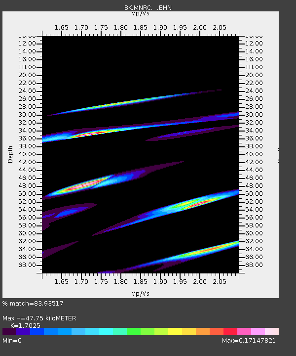
| Estimated Moho Depth: |
47.75 km |
| Estimated Crust Vp/Vs: |
1.70 |
| Assumed Crust Vp: |
6.472 km/s |
| Estimated Crust Vs: |
3.801 km/s |
| Estimated Crust Poisson's Ratio: |
0.24 |
|
| Radial Match: |
83.93517 % |
| Radial Bump: |
400 |
| Transverse Match: |
55.31435 % |
| Transverse Bump: |
400 |
| SOD ConfigId: |
124340 |
| Insert Time: |
2010-03-05 19:37:46.026 +0000 |
| GWidth: |
2.5 |
| Max Bumps: |
400 |
| Tol: |
0.001 |
|
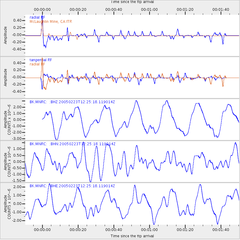
Signal To Noise
| Channel | StoN | STA | LTA |
| BK:MNRC: :BHN:20050223T12:25:18.119014Z | 0.7839738 | 6.671533E-7 | 8.509892E-7 |
| BK:MNRC: :BHE:20050223T12:25:18.119014Z | 1.1217325 | 1.2805295E-6 | 1.1415641E-6 |
| BK:MNRC: :BHZ:20050223T12:25:18.119014Z | 0.6720112 | 1.0150072E-6 | 1.5104024E-6 |
| Arrivals |
| Ps | 5.3 SECOND |
| PpPs | 20 SECOND |
| PsPs/PpSs | 25 SECOND |


