You are here: Home > Network List > GS - US Geological Survey Networks Stations List
> Station KAN13 Rinehart Farm, , CA, USA > Earthquake Result Viewer
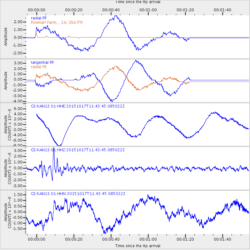
KAN13 Rinehart Farm, , CA, USA - Earthquake Result Viewer
*The percent match for this event was below the threshold and hence no stack was calculated.
| Earthquake location: |
Salta Province, Argentina |
| Earthquake latitude/longitude: |
-25.4/-64.4 |
| Earthquake time(UTC): |
2015/10/17 (290) 11:33:07 GMT |
| Earthquake Depth: |
8.2 km |
| Earthquake Magnitude: |
6.0 MB, 5.9 MWB |
| Earthquake Catalog/Contributor: |
NEIC PDE/NEIC COMCAT |
|
| Network: |
GS US Geological Survey Networks |
| Station: |
KAN13 Rinehart Farm, , CA, USA |
| Lat/Lon: |
37.01 N/97.48 W |
| Elevation: |
340 m |
|
| Distance: |
69.4 deg |
| Az: |
332.219 deg |
| Baz: |
148.223 deg |
| Ray Param: |
$rayparam |
*The percent match for this event was below the threshold and hence was not used in the summary stack. |
|
| Radial Match: |
35.22269 % |
| Radial Bump: |
400 |
| Transverse Match: |
33.455704 % |
| Transverse Bump: |
400 |
| SOD ConfigId: |
1259291 |
| Insert Time: |
2015-10-31 12:01:18.340 +0000 |
| GWidth: |
2.5 |
| Max Bumps: |
400 |
| Tol: |
0.001 |
|
Signal To Noise
| Channel | StoN | STA | LTA |
| GS:KAN13:01:HHZ:20151017T11:43:45.085022Z | 3.8565605 | 5.34154E-7 | 1.3850529E-7 |
| GS:KAN13:01:HHN:20151017T11:43:45.085022Z | 3.581432 | 1.6414543E-6 | 4.5832346E-7 |
| GS:KAN13:01:HHE:20151017T11:43:45.085022Z | 0.70706016 | 2.7882445E-6 | 3.943433E-6 |
| Arrivals |
| Ps | |
| PpPs | |
| PsPs/PpSs | |


