You are here: Home > Network List > BK - Berkeley Digital Seismograph Network Stations List
> Station MNRC McLaughlin Mine, CA > Earthquake Result Viewer
MNRC McLaughlin Mine, CA - Earthquake Result Viewer
| Earthquake location: |
New Ireland Region, P.N.G. |
| Earthquake latitude/longitude: |
-4.5/153.5 |
| Earthquake time(UTC): |
2005/09/09 (252) 07:26:43 GMT |
| Earthquake Depth: |
90 km |
| Earthquake Magnitude: |
6.3 MB, 7.7 MW, 7.5 MW |
| Earthquake Catalog/Contributor: |
WHDF/NEIC |
|
| Network: |
BK Berkeley Digital Seismograph Network |
| Station: |
MNRC McLaughlin Mine, CA |
| Lat/Lon: |
38.88 N/122.44 W |
| Elevation: |
710 m |
|
| Distance: |
88.2 deg |
| Az: |
50.964 deg |
| Baz: |
262.781 deg |
| Ray Param: |
0.042565912 |
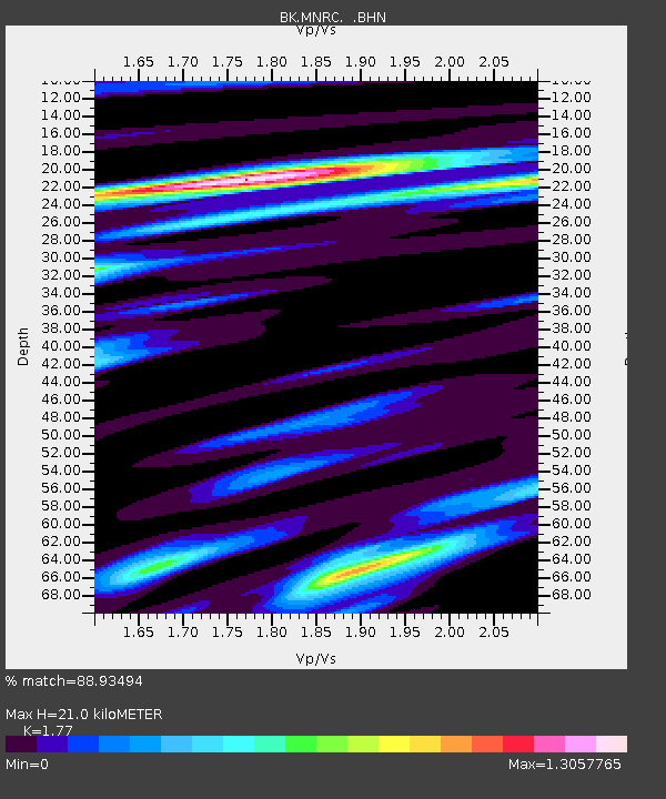
| Estimated Moho Depth: |
21.0 km |
| Estimated Crust Vp/Vs: |
1.77 |
| Assumed Crust Vp: |
6.472 km/s |
| Estimated Crust Vs: |
3.656 km/s |
| Estimated Crust Poisson's Ratio: |
0.27 |
|
| Radial Match: |
88.93494 % |
| Radial Bump: |
400 |
| Transverse Match: |
81.51127 % |
| Transverse Bump: |
400 |
| SOD ConfigId: |
2475 |
| Insert Time: |
2010-03-05 19:37:52.952 +0000 |
| GWidth: |
2.5 |
| Max Bumps: |
400 |
| Tol: |
0.001 |
|
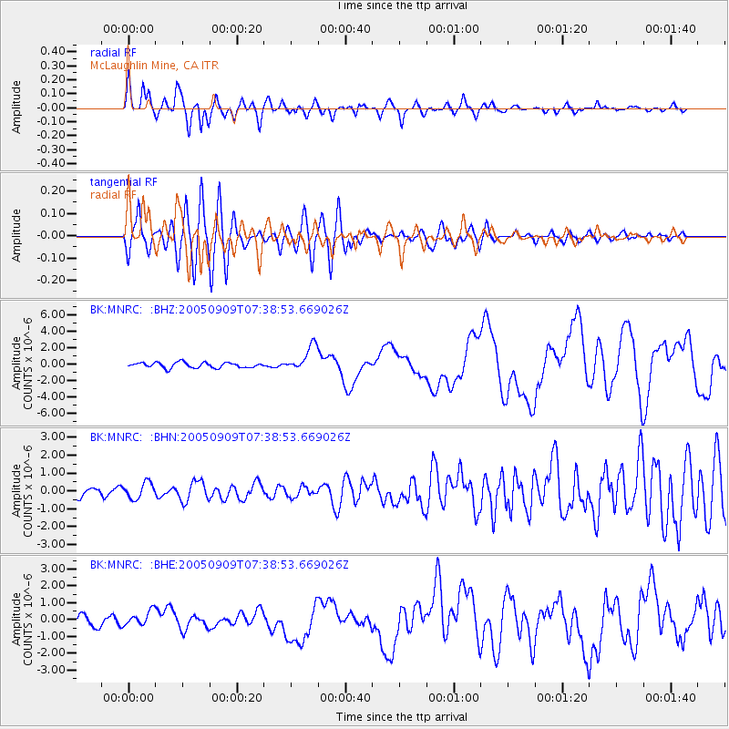
Signal To Noise
| Channel | StoN | STA | LTA |
| BK:MNRC: :BHN:20050909T07:38:53.669026Z | 1.1126186 | 4.5164612E-7 | 4.0593076E-7 |
| BK:MNRC: :BHE:20050909T07:38:53.669026Z | 1.3517293 | 4.4068085E-7 | 3.2601267E-7 |
| BK:MNRC: :BHZ:20050909T07:38:53.669026Z | 4.934627 | 1.5933844E-6 | 3.2289864E-7 |
| Arrivals |
| Ps | 2.6 SECOND |
| PpPs | 8.8 SECOND |
| PsPs/PpSs | 11 SECOND |


