You are here: Home > Network List > BK - Berkeley Digital Seismograph Network Stations List
> Station MNRC McLaughlin Mine, CA > Earthquake Result Viewer
MNRC McLaughlin Mine, CA - Earthquake Result Viewer
| Earthquake location: |
Northern Peru |
| Earthquake latitude/longitude: |
-5.7/-76.4 |
| Earthquake time(UTC): |
2005/09/26 (269) 01:55:37 GMT |
| Earthquake Depth: |
115 km |
| Earthquake Magnitude: |
6.7 MB, 7.5 MW, 7.5 MW |
| Earthquake Catalog/Contributor: |
WHDF/NEIC |
|
| Network: |
BK Berkeley Digital Seismograph Network |
| Station: |
MNRC McLaughlin Mine, CA |
| Lat/Lon: |
38.88 N/122.44 W |
| Elevation: |
710 m |
|
| Distance: |
61.5 deg |
| Az: |
320.239 deg |
| Baz: |
125.367 deg |
| Ray Param: |
0.060536645 |
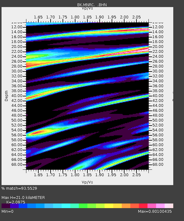
| Estimated Moho Depth: |
21.0 km |
| Estimated Crust Vp/Vs: |
2.10 |
| Assumed Crust Vp: |
6.472 km/s |
| Estimated Crust Vs: |
3.086 km/s |
| Estimated Crust Poisson's Ratio: |
0.35 |
|
| Radial Match: |
93.5529 % |
| Radial Bump: |
400 |
| Transverse Match: |
86.64102 % |
| Transverse Bump: |
400 |
| SOD ConfigId: |
2475 |
| Insert Time: |
2010-03-05 19:37:55.536 +0000 |
| GWidth: |
2.5 |
| Max Bumps: |
400 |
| Tol: |
0.001 |
|
Signal To Noise
| Channel | StoN | STA | LTA |
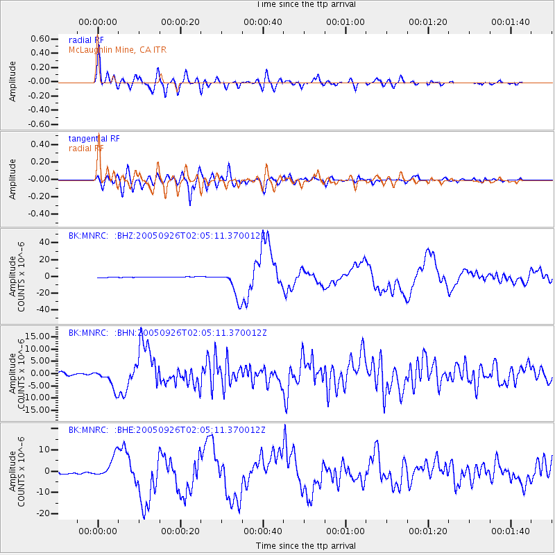
| BK:MNRC: :BHN:20050926T02:05:11.370012Z | 10.605723 | 4.1905864E-6 | 3.95125E-7 |
| BK:MNRC: :BHE:20050926T02:05:11.370012Z | 9.975002 | 5.382211E-6 | 5.3956984E-7 |
| BK:MNRC: :BHZ:20050926T02:05:11.370012Z | 49.191845 | 1.776475E-5 | 3.6113204E-7 |
| Arrivals |
| Ps | 3.7 SECOND |
| PpPs | 9.7 SECOND |
| PsPs/PpSs | 13 SECOND |


