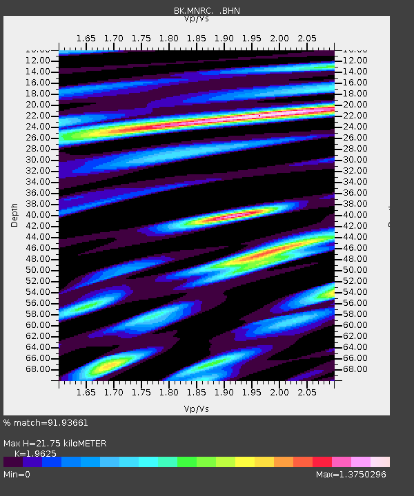
MNRC McLaughlin Mine, CA - Earthquake Result Viewer
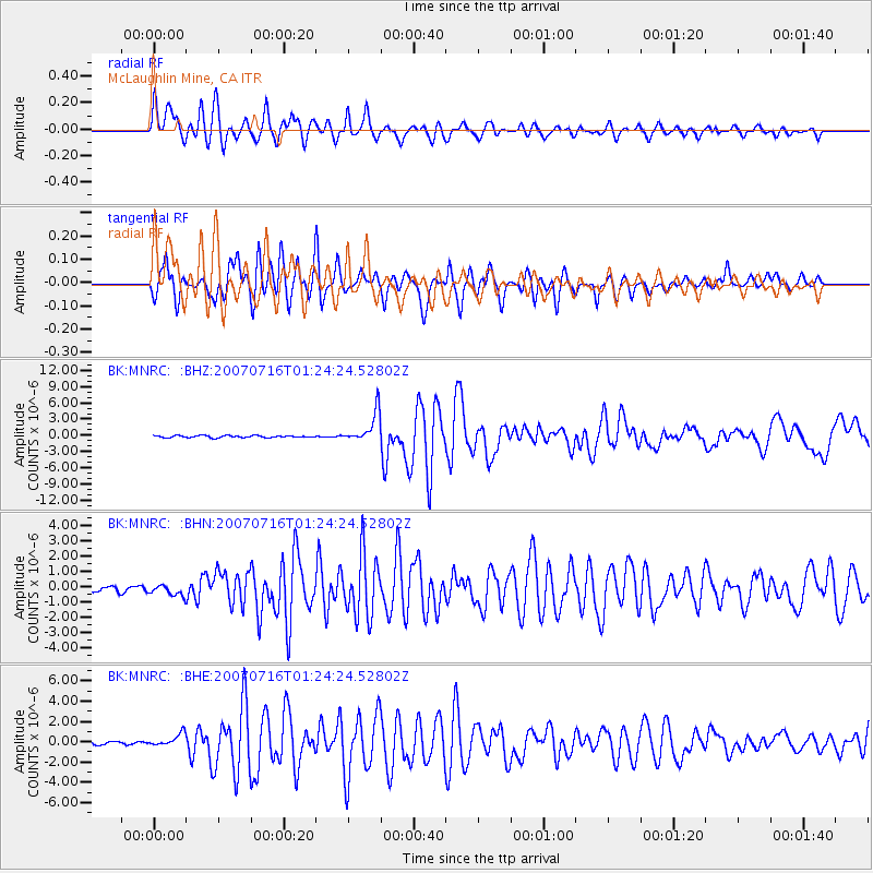
Earthquake location: Near West Coast Of Honshu, Japan
Earthquake latitude/longitude: 37.5/138.4
Earthquake time(UTC): 2007/07/16 (197) 01:13:22 GMT
Earthquake Depth: 12 km
Earthquake Magnitude: 6.5 MB, 6.4 MS, 6.6 MW, 6.5 MW
Earthquake Catalog/Contributor: WHDF/NEIC
Network: BK Berkeley Digital Seismograph Network
Station: MNRC McLaughlin Mine, CA
Lat/Lon: 38.88 N/122.44 W
Elevation: 710 m
Distance: 73.7 deg
Az: 53.421 deg
Baz: 305.128 deg
Ray Param: 0.052838434
Estimated Moho Depth: 21.75 km
Estimated Crust Vp/Vs: 1.96
Assumed Crust Vp: 6.472 km/s
Estimated Crust Vs: 3.298 km/s
Estimated Crust Poisson's Ratio: 0.32
Radial Match: 91.93661 %
Radial Bump: 400
Transverse Match: 78.673195 %
Transverse Bump: 400
SOD ConfigId: 2564
Insert Time: 2010-03-05 19:37:57.272 +0000
GWidth: 2.5
Max Bumps: 400
Tol: 0.001

Signal To Noise

ChannelStoNSTALTA
BK:MNRC: :BHN:20070716T01:24:24.52802Z1.40763123.316093E-72.3557968E-7
BK:MNRC: :BHE:20070716T01:24:24.52802Z2.60353976.124925E-72.3525375E-7
BK:MNRC: :BHZ:20070716T01:24:24.52802Z16.1503852.8078066E-61.7385386E-7
Arrivals
Ps3.3 SECOND
PpPs9.7 SECOND
PsPs/PpSs13 SECOND