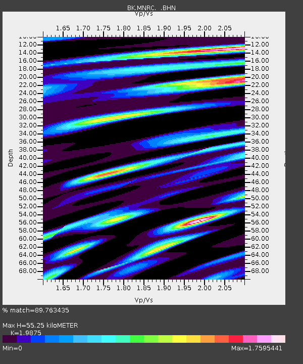
MNRC McLaughlin Mine, CA - Earthquake Result Viewer
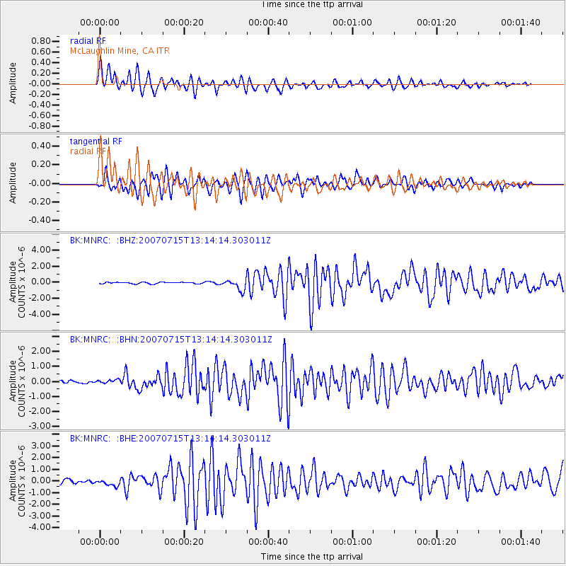
Earthquake location: Fox Islands, Aleutian Islands
Earthquake latitude/longitude: 52.5/-168.0
Earthquake time(UTC): 2007/07/15 (196) 13:08:00 GMT
Earthquake Depth: 10 km
Earthquake Magnitude: 5.8 MB, 5.9 MS, 6.1 MW, 6.0 MW
Earthquake Catalog/Contributor: WHDF/NEIC
Network: BK Berkeley Digital Seismograph Network
Station: MNRC McLaughlin Mine, CA
Lat/Lon: 38.88 N/122.44 W
Elevation: 710 m
Distance: 34.1 deg
Az: 95.091 deg
Baz: 308.693 deg
Ray Param: 0.07792574
Estimated Moho Depth: 55.25 km
Estimated Crust Vp/Vs: 1.99
Assumed Crust Vp: 6.472 km/s
Estimated Crust Vs: 3.256 km/s
Estimated Crust Poisson's Ratio: 0.33
Radial Match: 89.763435 %
Radial Bump: 400
Transverse Match: 84.53668 %
Transverse Bump: 400
SOD ConfigId: 2564
Insert Time: 2010-03-05 19:37:58.787 +0000
GWidth: 2.5
Max Bumps: 400
Tol: 0.001

Signal To Noise

ChannelStoNSTALTA
BK:MNRC: :BHN:20070715T13:14:14.303011Z1.47958781.1664442E-77.8835754E-8
BK:MNRC: :BHE:20070715T13:14:14.303011Z1.52827072.7368355E-71.7908054E-7
BK:MNRC: :BHZ:20070715T13:14:14.303011Z7.29891736.952533E-79.525431E-8
Arrivals
Ps9.0 SECOND
PpPs24 SECOND
PsPs/PpSs33 SECOND