You are here: Home > Network List > BK - Berkeley Digital Seismograph Network Stations List
> Station MNRC McLaughlin Mine, CA > Earthquake Result Viewer
MNRC McLaughlin Mine, CA - Earthquake Result Viewer
| Earthquake location: |
Solomon Islands |
| Earthquake latitude/longitude: |
-8.5/157.0 |
| Earthquake time(UTC): |
2007/04/01 (091) 20:39:56 GMT |
| Earthquake Depth: |
10 km |
| Earthquake Magnitude: |
6.8 MB, 7.9 MS, 8.1 MW, 7.7 ME |
| Earthquake Catalog/Contributor: |
WHDF/NEIC |
|
| Network: |
BK Berkeley Digital Seismograph Network |
| Station: |
MNRC McLaughlin Mine, CA |
| Lat/Lon: |
38.88 N/122.44 W |
| Elevation: |
710 m |
|
| Distance: |
87.9 deg |
| Az: |
50.386 deg |
| Baz: |
257.517 deg |
| Ray Param: |
0.042954896 |
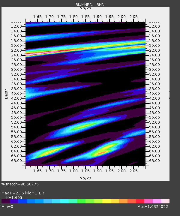
| Estimated Moho Depth: |
23.5 km |
| Estimated Crust Vp/Vs: |
1.61 |
| Assumed Crust Vp: |
6.472 km/s |
| Estimated Crust Vs: |
4.032 km/s |
| Estimated Crust Poisson's Ratio: |
0.18 |
|
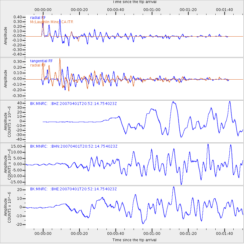
| Radial Match: |
96.50775 % |
| Radial Bump: |
400 |
| Transverse Match: |
90.68025 % |
| Transverse Bump: |
400 |
| SOD ConfigId: |
2564 |
| Insert Time: |
2010-03-05 19:38:08.305 +0000 |
| GWidth: |
2.5 |
| Max Bumps: |
400 |
| Tol: |
0.001 |
|
Signal To Noise
| Channel | StoN | STA | LTA |
| BK:MNRC: :BHN:20070401T20:52:14.754023Z | 1.4064996 | 4.086796E-7 | 2.9056503E-7 |
| BK:MNRC: :BHE:20070401T20:52:14.754023Z | 1.1449342 | 4.6203272E-7 | 4.0354524E-7 |
| BK:MNRC: :BHZ:20070401T20:52:14.754023Z | 8.184413 | 2.1462545E-6 | 2.6223682E-7 |
| Arrivals |
| Ps | 2.3 SECOND |
| PpPs | 9.2 SECOND |
| PsPs/PpSs | 11 SECOND |


