You are here: Home > Network List > BK - Berkeley Digital Seismograph Network Stations List
> Station MNRC McLaughlin Mine, CA > Earthquake Result Viewer
MNRC McLaughlin Mine, CA - Earthquake Result Viewer
| Earthquake location: |
Near West Coast Of Colombia |
| Earthquake latitude/longitude: |
3.0/-78.0 |
| Earthquake time(UTC): |
2007/09/10 (253) 01:49:14 GMT |
| Earthquake Depth: |
31 km |
| Earthquake Magnitude: |
6.1 MB, 6.7 MS, 6.8 MW |
| Earthquake Catalog/Contributor: |
WHDF/NEIC |
|
| Network: |
BK Berkeley Digital Seismograph Network |
| Station: |
MNRC McLaughlin Mine, CA |
| Lat/Lon: |
38.88 N/122.44 W |
| Elevation: |
710 m |
|
| Distance: |
53.9 deg |
| Az: |
317.439 deg |
| Baz: |
120.072 deg |
| Ray Param: |
0.06570071 |
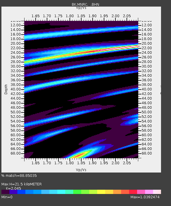
| Estimated Moho Depth: |
21.5 km |
| Estimated Crust Vp/Vs: |
2.05 |
| Assumed Crust Vp: |
6.472 km/s |
| Estimated Crust Vs: |
3.165 km/s |
| Estimated Crust Poisson's Ratio: |
0.34 |
|
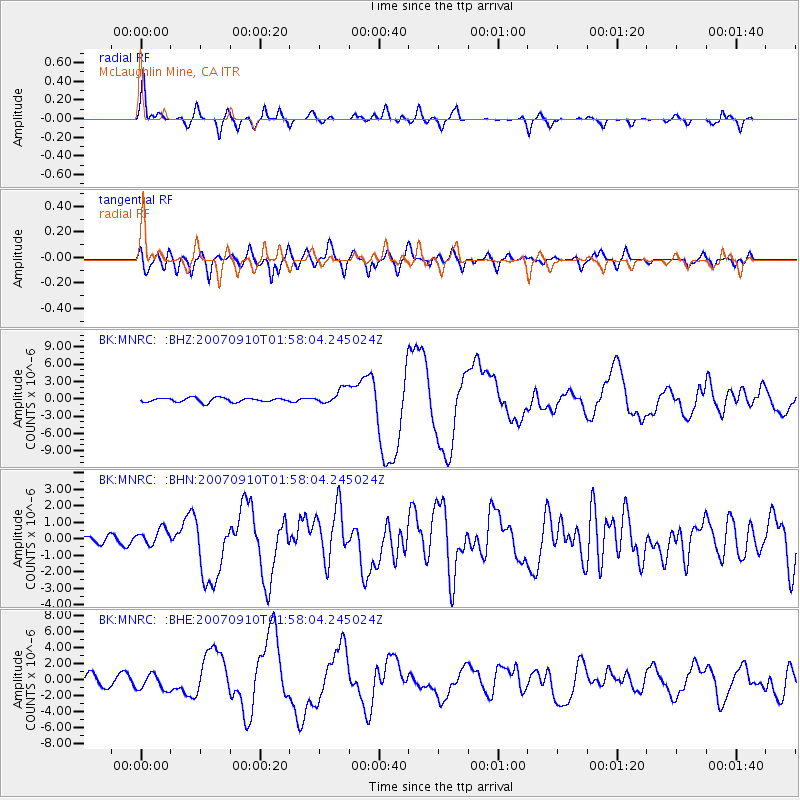
| Radial Match: |
88.85035 % |
| Radial Bump: |
400 |
| Transverse Match: |
71.73915 % |
| Transverse Bump: |
400 |
| SOD ConfigId: |
2564 |
| Insert Time: |
2010-03-05 19:38:18.436 +0000 |
| GWidth: |
2.5 |
| Max Bumps: |
400 |
| Tol: |
0.001 |
|
Signal To Noise
| Channel | StoN | STA | LTA |
| BK:MNRC: :BHN:20070910T01:58:04.245024Z | 1.3908219 | 5.157179E-7 | 3.7080082E-7 |
| BK:MNRC: :BHE:20070910T01:58:04.245024Z | 1.5513058 | 9.905077E-7 | 6.3849933E-7 |
| BK:MNRC: :BHZ:20070910T01:58:04.245024Z | 3.8010387 | 1.3552738E-6 | 3.565535E-7 |
| Arrivals |
| Ps | 3.6 SECOND |
| PpPs | 9.7 SECOND |
| PsPs/PpSs | 13 SECOND |


