You are here: Home > Network List > PB - Plate Boundary Observatory Borehole Seismic Network Stations List
> Station B087 fordra087bcs2006, Anza, CA, USA > Earthquake Result Viewer
B087 fordra087bcs2006, Anza, CA, USA - Earthquake Result Viewer
| Earthquake location: |
La Rioja Province, Argentina |
| Earthquake latitude/longitude: |
-28.9/-67.5 |
| Earthquake time(UTC): |
2016/11/13 (318) 14:01:01 GMT |
| Earthquake Depth: |
110 km |
| Earthquake Magnitude: |
6.2 MB, 5.7 MWR |
| Earthquake Catalog/Contributor: |
NEIC PDE/NEIC COMCAT |
|
| Network: |
PB Plate Boundary Observatory Borehole Seismic Network |
| Station: |
B087 fordra087bcs2006, Anza, CA, USA |
| Lat/Lon: |
33.50 N/116.60 W |
| Elevation: |
1139 m |
|
| Distance: |
77.5 deg |
| Az: |
319.671 deg |
| Baz: |
137.214 deg |
| Ray Param: |
0.049991407 |
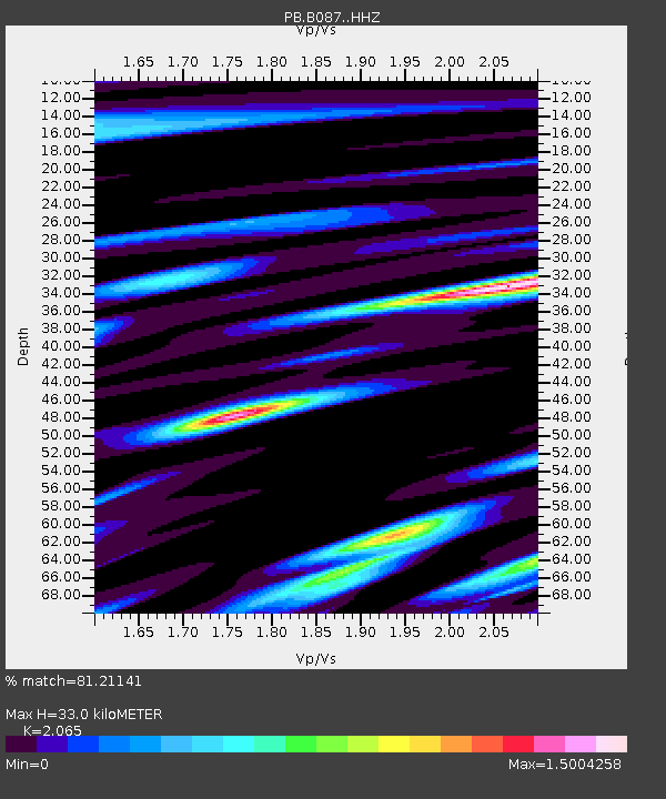
| Estimated Moho Depth: |
33.0 km |
| Estimated Crust Vp/Vs: |
2.07 |
| Assumed Crust Vp: |
6.264 km/s |
| Estimated Crust Vs: |
3.033 km/s |
| Estimated Crust Poisson's Ratio: |
0.35 |
|
| Radial Match: |
81.21141 % |
| Radial Bump: |
400 |
| Transverse Match: |
71.53841 % |
| Transverse Bump: |
400 |
| SOD ConfigId: |
11737051 |
| Insert Time: |
2019-04-26 01:51:05.269 +0000 |
| GWidth: |
2.5 |
| Max Bumps: |
400 |
| Tol: |
0.001 |
|

Signal To Noise
| Channel | StoN | STA | LTA |
| PB:B087: :HHZ:20161113T14:12:14.563987Z | 20.736599 | 8.819063E-8 | 4.2528976E-9 |
| PB:B087: :HH1:20161113T14:12:14.563987Z | 1.4750992 | 1.6644552E-8 | 1.1283683E-8 |
| PB:B087: :HH2:20161113T14:12:14.563987Z | 4.2684307 | 1.9330779E-8 | 4.528779E-9 |
| Arrivals |
| Ps | 5.8 SECOND |
| PpPs | 16 SECOND |
| PsPs/PpSs | 22 SECOND |


