You are here: Home > Network List > TA - USArray Transportable Network (new EarthScope stations) Stations List
> Station L44A Lake County Forest Preserve, Grayslake, IL, USA > Earthquake Result Viewer
L44A Lake County Forest Preserve, Grayslake, IL, USA - Earthquake Result Viewer
| Earthquake location: |
La Rioja Province, Argentina |
| Earthquake latitude/longitude: |
-28.9/-67.5 |
| Earthquake time(UTC): |
2016/11/13 (318) 14:01:01 GMT |
| Earthquake Depth: |
110 km |
| Earthquake Magnitude: |
6.2 MB, 5.7 MWR |
| Earthquake Catalog/Contributor: |
NEIC PDE/NEIC COMCAT |
|
| Network: |
TA USArray Transportable Network (new EarthScope stations) |
| Station: |
L44A Lake County Forest Preserve, Grayslake, IL, USA |
| Lat/Lon: |
42.18 N/87.91 W |
| Elevation: |
202 m |
|
| Distance: |
73.2 deg |
| Az: |
344.262 deg |
| Baz: |
161.334 deg |
| Ray Param: |
0.052911818 |
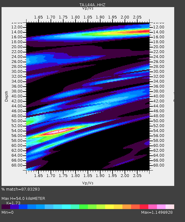
| Estimated Moho Depth: |
54.0 km |
| Estimated Crust Vp/Vs: |
1.73 |
| Assumed Crust Vp: |
6.483 km/s |
| Estimated Crust Vs: |
3.747 km/s |
| Estimated Crust Poisson's Ratio: |
0.25 |
|
| Radial Match: |
87.83293 % |
| Radial Bump: |
400 |
| Transverse Match: |
59.451305 % |
| Transverse Bump: |
400 |
| SOD ConfigId: |
11737051 |
| Insert Time: |
2019-04-26 01:51:58.619 +0000 |
| GWidth: |
2.5 |
| Max Bumps: |
400 |
| Tol: |
0.001 |
|

Signal To Noise
| Channel | StoN | STA | LTA |
| TA:L44A: :HHZ:20161113T14:11:49.599998Z | 0.95253843 | 2.482576E-6 | 2.606274E-6 |
| TA:L44A: :HHN:20161113T14:11:49.599998Z | 2.2409375 | 1.9841448E-6 | 8.854083E-7 |
| TA:L44A: :HHE:20161113T14:11:49.599998Z | 1.6716226 | 1.8829702E-6 | 1.1264326E-6 |
| Arrivals |
| Ps | 6.3 SECOND |
| PpPs | 22 SECOND |
| PsPs/PpSs | 28 SECOND |


