You are here: Home > Network List > BK - Berkeley Digital Seismograph Network Stations List
> Station MNRC McLaughlin Mine, CA > Earthquake Result Viewer
MNRC McLaughlin Mine, CA - Earthquake Result Viewer
| Earthquake location: |
Hokkaido, Japan Region |
| Earthquake latitude/longitude: |
42.9/145.2 |
| Earthquake time(UTC): |
2004/12/06 (341) 14:15:11 GMT |
| Earthquake Depth: |
35 km |
| Earthquake Magnitude: |
6.5 MB, 6.5 MS, 6.8 MW, 6.8 MW |
| Earthquake Catalog/Contributor: |
WHDF/NEIC |
|
| Network: |
BK Berkeley Digital Seismograph Network |
| Station: |
MNRC McLaughlin Mine, CA |
| Lat/Lon: |
38.88 N/122.44 W |
| Elevation: |
710 m |
|
| Distance: |
66.4 deg |
| Az: |
58.343 deg |
| Baz: |
306.741 deg |
| Ray Param: |
0.057598073 |
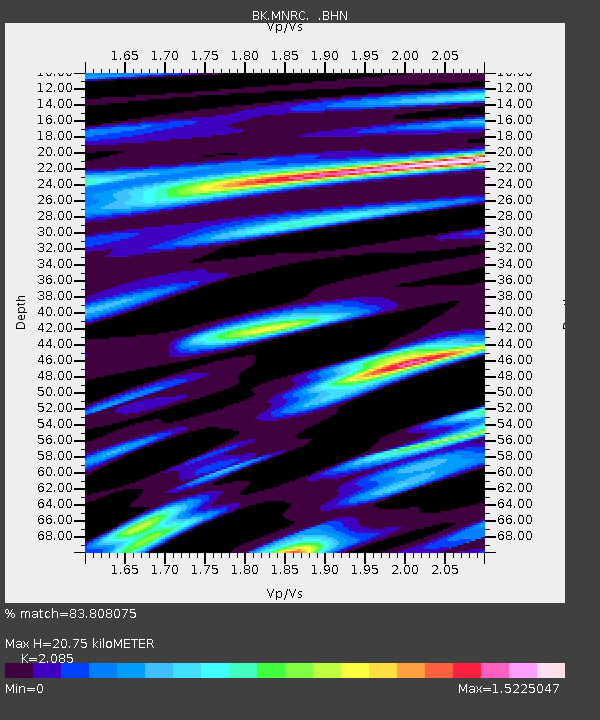
| Estimated Moho Depth: |
20.75 km |
| Estimated Crust Vp/Vs: |
2.09 |
| Assumed Crust Vp: |
6.472 km/s |
| Estimated Crust Vs: |
3.104 km/s |
| Estimated Crust Poisson's Ratio: |
0.35 |
|
| Radial Match: |
83.808075 % |
| Radial Bump: |
400 |
| Transverse Match: |
73.77348 % |
| Transverse Bump: |
400 |
| SOD ConfigId: |
2459 |
| Insert Time: |
2010-03-05 19:38:29.160 +0000 |
| GWidth: |
2.5 |
| Max Bumps: |
400 |
| Tol: |
0.001 |
|
Signal To Noise
| Channel | StoN | STA | LTA |
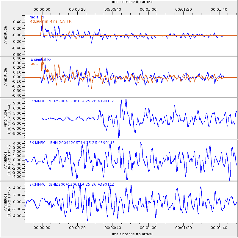
| BK:MNRC: :BHN:20041206T14:25:26.439011Z | 2.4021728 | 1.1076147E-6 | 4.6108866E-7 |
| BK:MNRC: :BHE:20041206T14:25:26.439011Z | 0.7938455 | 7.3075046E-7 | 9.205197E-7 |
| BK:MNRC: :BHZ:20041206T14:25:26.439011Z | 3.4768558 | 2.1753149E-6 | 6.256558E-7 |
| Arrivals |
| Ps | 3.6 SECOND |
| PpPs | 9.6 SECOND |
| PsPs/PpSs | 13 SECOND |


