You are here: Home > Network List > BK - Berkeley Digital Seismograph Network Stations List
> Station MNRC McLaughlin Mine, CA > Earthquake Result Viewer
MNRC McLaughlin Mine, CA - Earthquake Result Viewer
| Earthquake location: |
Hokkaido, Japan Region |
| Earthquake latitude/longitude: |
43.0/145.1 |
| Earthquake time(UTC): |
2004/11/28 (333) 18:32:14 GMT |
| Earthquake Depth: |
39 km |
| Earthquake Magnitude: |
6.4 MB, 6.7 MS, 7.0 MW, 7.0 MW |
| Earthquake Catalog/Contributor: |
WHDF/NEIC |
|
| Network: |
BK Berkeley Digital Seismograph Network |
| Station: |
MNRC McLaughlin Mine, CA |
| Lat/Lon: |
38.88 N/122.44 W |
| Elevation: |
710 m |
|
| Distance: |
66.4 deg |
| Az: |
58.327 deg |
| Baz: |
306.885 deg |
| Ray Param: |
0.057577446 |
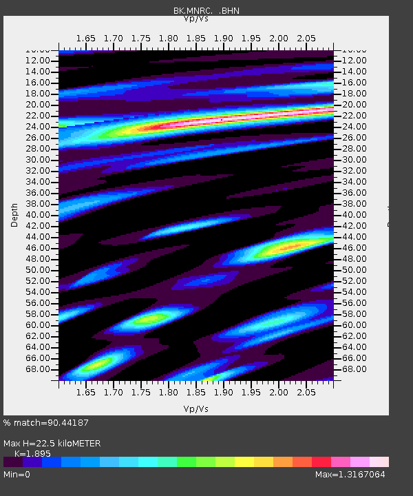
| Estimated Moho Depth: |
22.5 km |
| Estimated Crust Vp/Vs: |
1.89 |
| Assumed Crust Vp: |
6.472 km/s |
| Estimated Crust Vs: |
3.415 km/s |
| Estimated Crust Poisson's Ratio: |
0.31 |
|
| Radial Match: |
90.44187 % |
| Radial Bump: |
400 |
| Transverse Match: |
86.49914 % |
| Transverse Bump: |
400 |
| SOD ConfigId: |
2459 |
| Insert Time: |
2010-03-05 19:38:31.024 +0000 |
| GWidth: |
2.5 |
| Max Bumps: |
400 |
| Tol: |
0.001 |
|
Signal To Noise
| Channel | StoN | STA | LTA |
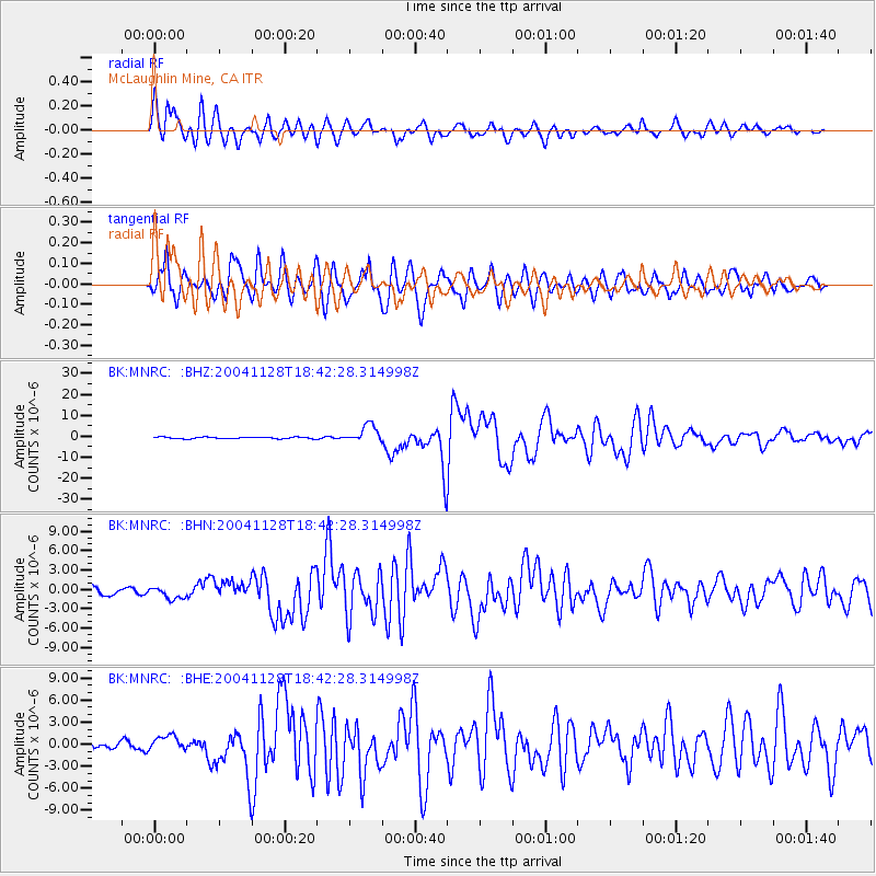
| BK:MNRC: :BHN:20041128T18:42:28.314998Z | 1.8260295 | 9.054833E-7 | 4.958755E-7 |
| BK:MNRC: :BHE:20041128T18:42:28.314998Z | 2.7412524 | 1.0581688E-6 | 3.8601655E-7 |
| BK:MNRC: :BHZ:20041128T18:42:28.314998Z | 10.695231 | 4.1730946E-6 | 3.9018275E-7 |
| Arrivals |
| Ps | 3.2 SECOND |
| PpPs | 9.7 SECOND |
| PsPs/PpSs | 13 SECOND |


