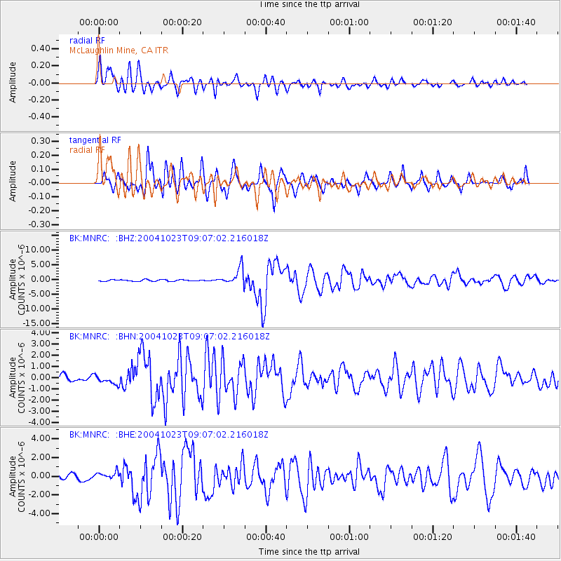
MNRC McLaughlin Mine, CA - Earthquake Result Viewer
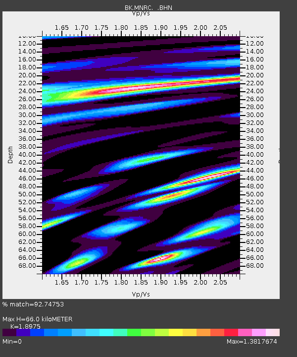
Earthquake location: Near West Coast Of Honshu, Japan
Earthquake latitude/longitude: 37.2/138.8
Earthquake time(UTC): 2004/10/23 (297) 08:56:00 GMT
Earthquake Depth: 16 km
Earthquake Magnitude: 6.4 MB, 6.3 MS, 6.6 MW, 6.4 MW
Earthquake Catalog/Contributor: WHDF/NEIC
Network: BK Berkeley Digital Seismograph Network
Station: MNRC McLaughlin Mine, CA
Lat/Lon: 38.88 N/122.44 W
Elevation: 710 m
Distance: 73.7 deg
Az: 53.503 deg
Baz: 304.705 deg
Ray Param: 0.05285032
Estimated Moho Depth: 66.0 km
Estimated Crust Vp/Vs: 1.90
Assumed Crust Vp: 6.472 km/s
Estimated Crust Vs: 3.411 km/s
Estimated Crust Poisson's Ratio: 0.31
Radial Match: 92.74753 %
Radial Bump: 400
Transverse Match: 81.68563 %
Transverse Bump: 400
SOD ConfigId: 2459
Insert Time: 2010-03-05 19:38:33.895 +0000
GWidth: 2.5
Max Bumps: 400
Tol: 0.001

Signal To Noise

ChannelStoNSTALTA
BK:MNRC: :BHN:20041023T09:07:02.216018Z1.45414713.9972971E-72.7488946E-7
BK:MNRC: :BHE:20041023T09:07:02.216018Z1.00127144.1241387E-74.1189023E-7
BK:MNRC: :BHZ:20041023T09:07:02.216018Z11.7225832.9619985E-62.5267457E-7
Arrivals
Ps9.5 SECOND
PpPs29 SECOND
PsPs/PpSs38 SECOND