You are here: Home > Network List > BK - Berkeley Digital Seismograph Network Stations List
> Station MNRC McLaughlin Mine, CA > Earthquake Result Viewer
MNRC McLaughlin Mine, CA - Earthquake Result Viewer
| Earthquake location: |
Samoa Islands Region |
| Earthquake latitude/longitude: |
-16.6/-172.0 |
| Earthquake time(UTC): |
2006/09/28 (271) 06:22:09 GMT |
| Earthquake Depth: |
28 km |
| Earthquake Magnitude: |
6.5 MB, 6.6 MS, 6.9 MW, 6.7 MW |
| Earthquake Catalog/Contributor: |
WHDF/NEIC |
|
| Network: |
BK Berkeley Digital Seismograph Network |
| Station: |
MNRC McLaughlin Mine, CA |
| Lat/Lon: |
38.88 N/122.44 W |
| Elevation: |
710 m |
|
| Distance: |
72.1 deg |
| Az: |
38.656 deg |
| Baz: |
230.118 deg |
| Ray Param: |
0.05386437 |
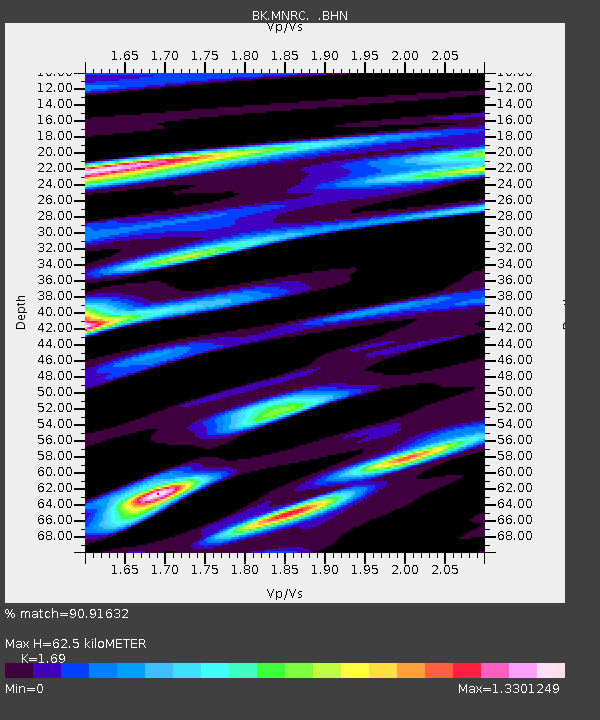
| Estimated Moho Depth: |
62.5 km |
| Estimated Crust Vp/Vs: |
1.69 |
| Assumed Crust Vp: |
6.472 km/s |
| Estimated Crust Vs: |
3.83 km/s |
| Estimated Crust Poisson's Ratio: |
0.23 |
|
| Radial Match: |
90.91632 % |
| Radial Bump: |
400 |
| Transverse Match: |
89.93587 % |
| Transverse Bump: |
400 |
| SOD ConfigId: |
2665 |
| Insert Time: |
2010-03-05 19:38:52.091 +0000 |
| GWidth: |
2.5 |
| Max Bumps: |
400 |
| Tol: |
0.001 |
|
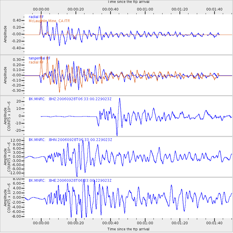
Signal To Noise
| Channel | StoN | STA | LTA |
| BK:MNRC: :BHN:20060928T06:33:00.229023Z | 4.11465 | 1.3098927E-6 | 3.1834853E-7 |
| BK:MNRC: :BHE:20060928T06:33:00.229023Z | 4.268916 | 9.698359E-7 | 2.2718551E-7 |
| BK:MNRC: :BHZ:20060928T06:33:00.229023Z | 17.212269 | 4.889179E-6 | 2.8405196E-7 |
| Arrivals |
| Ps | 6.9 SECOND |
| PpPs | 25 SECOND |
| PsPs/PpSs | 32 SECOND |


