You are here: Home > Network List > BK - Berkeley Digital Seismograph Network Stations List
> Station MNRC McLaughlin Mine, CA > Earthquake Result Viewer
MNRC McLaughlin Mine, CA - Earthquake Result Viewer
| Earthquake location: |
Solomon Islands |
| Earthquake latitude/longitude: |
-6.8/155.5 |
| Earthquake time(UTC): |
2006/09/01 (244) 10:18:51 GMT |
| Earthquake Depth: |
38 km |
| Earthquake Magnitude: |
6.3 MB, 6.7 MS, 6.8 MW, 6.7 MW |
| Earthquake Catalog/Contributor: |
WHDF/NEIC |
|
| Network: |
BK Berkeley Digital Seismograph Network |
| Station: |
MNRC McLaughlin Mine, CA |
| Lat/Lon: |
38.88 N/122.44 W |
| Elevation: |
710 m |
|
| Distance: |
88.0 deg |
| Az: |
50.667 deg |
| Baz: |
259.789 deg |
| Ray Param: |
0.042828016 |
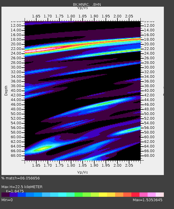
| Estimated Moho Depth: |
22.5 km |
| Estimated Crust Vp/Vs: |
1.65 |
| Assumed Crust Vp: |
6.472 km/s |
| Estimated Crust Vs: |
3.928 km/s |
| Estimated Crust Poisson's Ratio: |
0.21 |
|
| Radial Match: |
86.056656 % |
| Radial Bump: |
400 |
| Transverse Match: |
58.070503 % |
| Transverse Bump: |
400 |
| SOD ConfigId: |
2665 |
| Insert Time: |
2010-03-05 19:38:54.997 +0000 |
| GWidth: |
2.5 |
| Max Bumps: |
400 |
| Tol: |
0.001 |
|
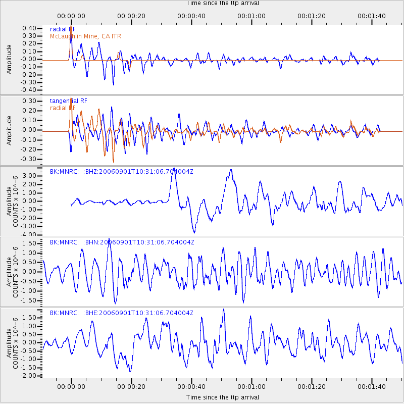
Signal To Noise
| Channel | StoN | STA | LTA |
| BK:MNRC: :BHN:20060901T10:31:06.704004Z | 1.777074 | 7.056897E-7 | 3.9710764E-7 |
| BK:MNRC: :BHE:20060901T10:31:06.704004Z | 1.9492537 | 5.084215E-7 | 2.608288E-7 |
| BK:MNRC: :BHZ:20060901T10:31:06.704004Z | 10.792986 | 1.8998193E-6 | 1.7602352E-7 |
| Arrivals |
| Ps | 2.3 SECOND |
| PpPs | 9.0 SECOND |
| PsPs/PpSs | 11 SECOND |


