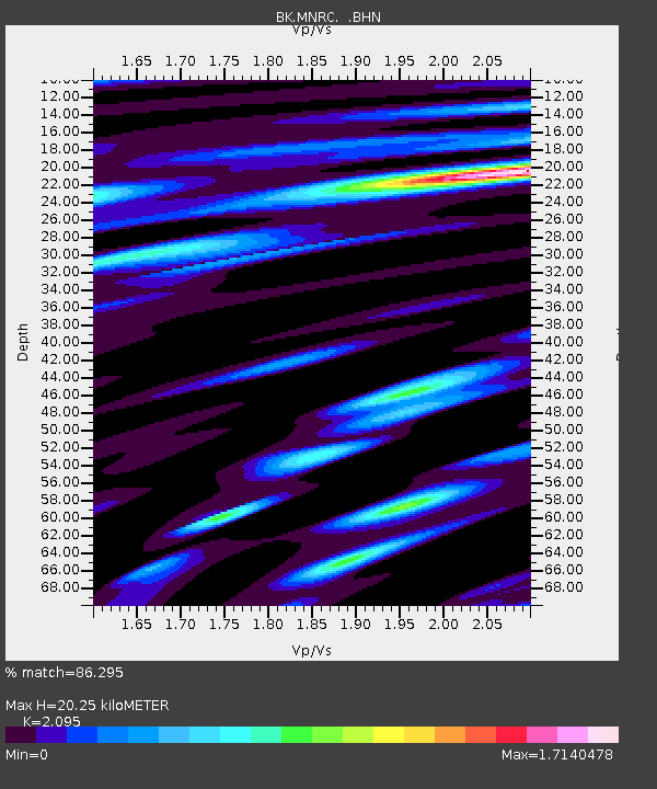
MNRC McLaughlin Mine, CA - Earthquake Result Viewer
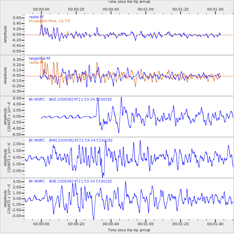
Earthquake location: Near East Coast Of Kamchatka
Earthquake latitude/longitude: 51.1/157.5
Earthquake time(UTC): 2006/08/24 (236) 21:50:36 GMT
Earthquake Depth: 43 km
Earthquake Magnitude: 5.9 MB, 6.2 MS, 6.5 MW, 6.5 MW
Earthquake Catalog/Contributor: WHDF/NEIC
Network: BK Berkeley Digital Seismograph Network
Station: MNRC McLaughlin Mine, CA
Lat/Lon: 38.88 N/122.44 W
Elevation: 710 m
Distance: 55.2 deg
Az: 69.408 deg
Baz: 310.939 deg
Ray Param: 0.06484908
Estimated Moho Depth: 20.25 km
Estimated Crust Vp/Vs: 2.10
Assumed Crust Vp: 6.472 km/s
Estimated Crust Vs: 3.089 km/s
Estimated Crust Poisson's Ratio: 0.35
Radial Match: 86.295 %
Radial Bump: 400
Transverse Match: 83.4182 %
Transverse Bump: 400
SOD ConfigId: 2665
Insert Time: 2010-03-05 19:38:56.367 +0000
GWidth: 2.5
Max Bumps: 400
Tol: 0.001

Signal To Noise

ChannelStoNSTALTA
BK:MNRC: :BHN:20060824T21:59:34.529028Z2.46754225.394632E-72.1862371E-7
BK:MNRC: :BHE:20060824T21:59:34.529028Z1.84765616.030923E-73.2640938E-7
BK:MNRC: :BHZ:20060824T21:59:34.529028Z9.8079062.7564474E-62.810434E-7
Arrivals
Ps3.6 SECOND
PpPs9.3 SECOND
PsPs/PpSs13 SECOND