You are here: Home > Network List > YT07 - POLENET Stations List
> Station MA10 Polenet mini-array MA10 > Earthquake Result Viewer
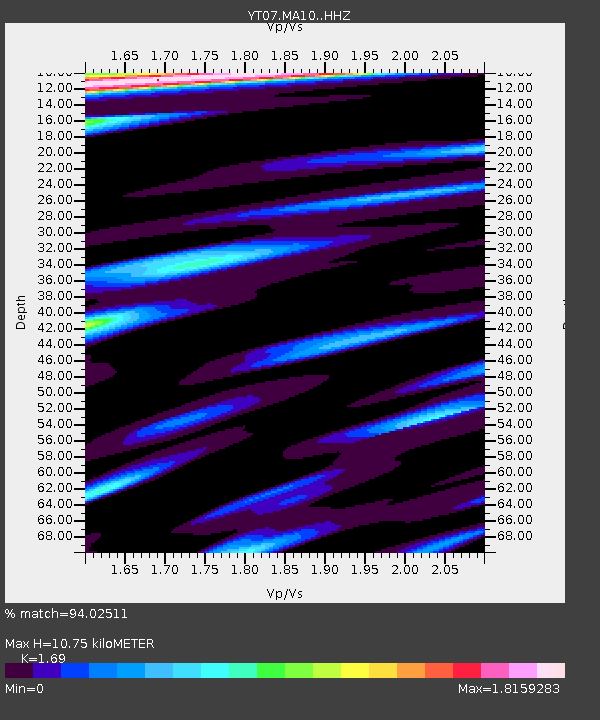
MA10 Polenet mini-array MA10 - Earthquake Result Viewer
| Earthquake location: |
South Island, New Zealand |
| Earthquake latitude/longitude: |
-42.6/173.3 |
| Earthquake time(UTC): |
2016/11/14 (319) 00:34:22 GMT |
| Earthquake Depth: |
10 km |
| Earthquake Magnitude: |
6.5 MWW, 6.3 MWB, 6.8 MI |
| Earthquake Catalog/Contributor: |
NEIC PDE/NEIC COMCAT |
|
| Network: |
YT POLENET |
| Station: |
MA10 Polenet mini-array MA10 |
| Lat/Lon: |
78.60 S/109.00 W |
| Elevation: |
1658 m |
|
| Distance: |
46.2 deg |
| Az: |
164.379 deg |
| Baz: |
271.576 deg |
| Ray Param: |
0.07078499 |
| Estimated Moho Depth: |
10.75 km |
| Estimated Crust Vp/Vs: |
1.69 |
| Assumed Crust Vp: |
5.872 km/s |
| Estimated Crust Vs: |
3.475 km/s |
| Estimated Crust Poisson's Ratio: |
0.23 |
|
| Radial Match: |
94.02511 % |
| Radial Bump: |
380 |
| Transverse Match: |
86.59986 % |
| Transverse Bump: |
400 |
| SOD ConfigId: |
11737051 |
| Insert Time: |
2019-04-26 01:59:22.714 +0000 |
| GWidth: |
2.5 |
| Max Bumps: |
400 |
| Tol: |
0.001 |
|

Signal To Noise
| Channel | StoN | STA | LTA |
| YT:MA10: :HHZ:20161114T00:42:16.789003Z | 2.2112603 | 2.0139689E-7 | 9.107787E-8 |
| YT:MA10: :HHN:20161114T00:42:16.789003Z | 0.5553624 | 8.7623725E-8 | 1.5777755E-7 |
| YT:MA10: :HHE:20161114T00:42:16.789003Z | 1.3011993 | 1.4754231E-7 | 1.13389476E-7 |
| Arrivals |
| Ps | 1.3 SECOND |
| PpPs | 4.7 SECOND |
| PsPs/PpSs | 6.0 SECOND |


