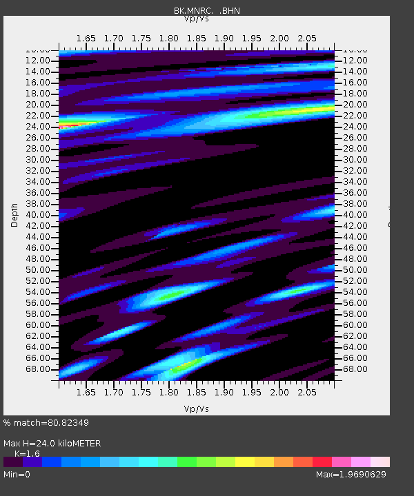
MNRC McLaughlin Mine, CA - Earthquake Result Viewer
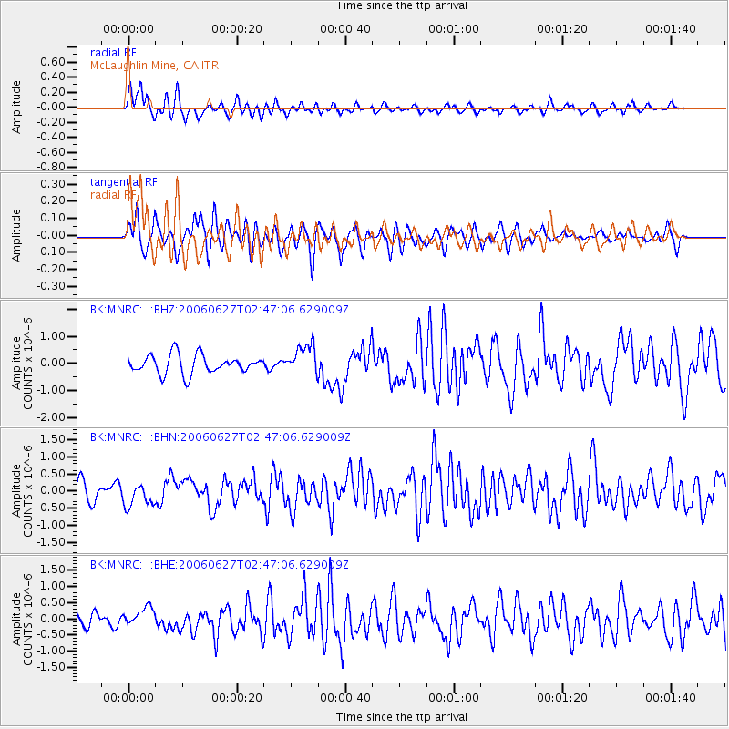
Earthquake location: Rat Islands, Aleutian Islands
Earthquake latitude/longitude: 52.2/176.2
Earthquake time(UTC): 2006/06/27 (178) 02:39:35 GMT
Earthquake Depth: 34 km
Earthquake Magnitude: 5.6 MB, 6.0 MS, 6.2 MW, 6.2 MW
Earthquake Catalog/Contributor: WHDF/NEIC
Network: BK Berkeley Digital Seismograph Network
Station: MNRC McLaughlin Mine, CA
Lat/Lon: 38.88 N/122.44 W
Elevation: 710 m
Distance: 43.7 deg
Az: 82.52 deg
Baz: 308.58 deg
Ray Param: 0.07230561
Estimated Moho Depth: 24.0 km
Estimated Crust Vp/Vs: 1.60
Assumed Crust Vp: 6.472 km/s
Estimated Crust Vs: 4.045 km/s
Estimated Crust Poisson's Ratio: 0.18
Radial Match: 80.82349 %
Radial Bump: 400
Transverse Match: 66.52158 %
Transverse Bump: 400
SOD ConfigId: 2665
Insert Time: 2010-03-05 19:38:57.769 +0000
GWidth: 2.5
Max Bumps: 400
Tol: 0.001

Signal To Noise

ChannelStoNSTALTA
BK:MNRC: :BHN:20060627T02:47:06.629009Z1.28199063.273726E-72.553627E-7
BK:MNRC: :BHE:20060627T02:47:06.629009Z1.26037992.9771476E-72.3621034E-7
BK:MNRC: :BHZ:20060627T02:47:06.629009Z1.58203925.455014E-73.4480902E-7
Arrivals
Ps2.4 SECOND
PpPs9.0 SECOND
PsPs/PpSs11 SECOND