You are here: Home > Network List > CI - Caltech Regional Seismic Network Stations List
> Station MPM Manuel Prospect Mine, California, USA > Earthquake Result Viewer
MPM Manuel Prospect Mine, California, USA - Earthquake Result Viewer
*The percent match for this event was below the threshold and hence no stack was calculated.
| Earthquake location: |
Rat Islands, Aleutian Islands |
| Earthquake latitude/longitude: |
51.1/178.8 |
| Earthquake time(UTC): |
2016/11/14 (319) 02:12:17 GMT |
| Earthquake Depth: |
34 km |
| Earthquake Magnitude: |
5.6 MWW, 5.0 ML, 5.4 ML |
| Earthquake Catalog/Contributor: |
NEIC PDE/NEIC COMCAT |
|
| Network: |
CI Caltech Regional Seismic Network |
| Station: |
MPM Manuel Prospect Mine, California, USA |
| Lat/Lon: |
36.06 N/117.49 W |
| Elevation: |
185 m |
|
| Distance: |
47.0 deg |
| Az: |
82.869 deg |
| Baz: |
309.417 deg |
| Ray Param: |
$rayparam |
*The percent match for this event was below the threshold and hence was not used in the summary stack. |
|
| Radial Match: |
67.37763 % |
| Radial Bump: |
400 |
| Transverse Match: |
71.516426 % |
| Transverse Bump: |
400 |
| SOD ConfigId: |
11737051 |
| Insert Time: |
2019-04-26 02:02:13.317 +0000 |
| GWidth: |
2.5 |
| Max Bumps: |
400 |
| Tol: |
0.001 |
|
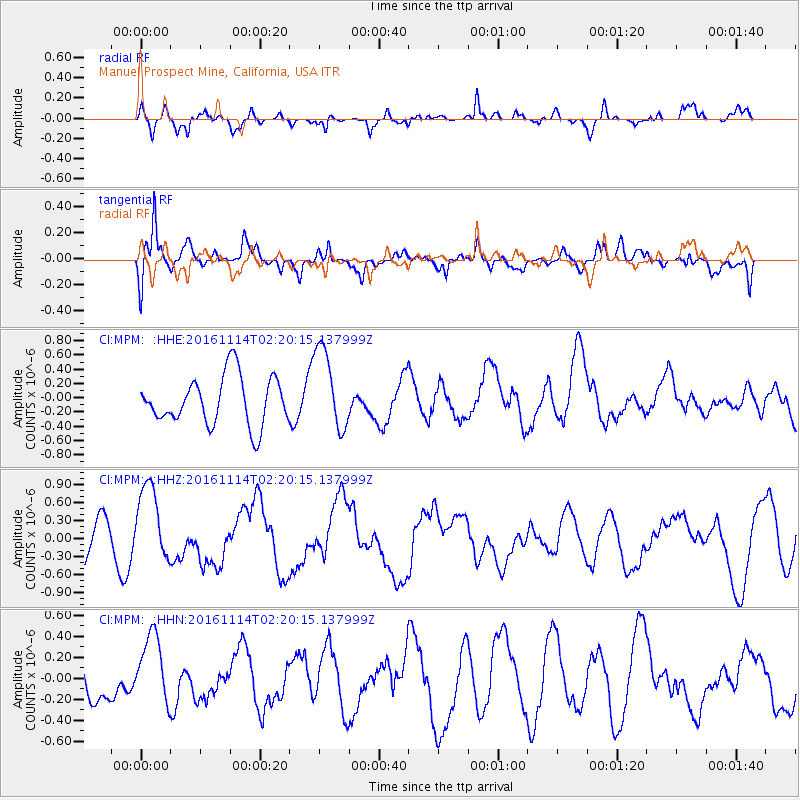
Signal To Noise
| Channel | StoN | STA | LTA |
| CI:MPM: :HHZ:20161114T02:20:15.137999Z | 2.0526986 | 6.6090564E-7 | 3.2196914E-7 |
| CI:MPM: :HHN:20161114T02:20:15.137999Z | 1.3730085 | 3.3070984E-7 | 2.4086512E-7 |
| CI:MPM: :HHE:20161114T02:20:15.137999Z | 1.7115095 | 5.7934966E-7 | 3.3850213E-7 |
| Arrivals |
| Ps | |
| PpPs | |
| PsPs/PpSs | |


