You are here: Home > Network List > BK - Berkeley Digital Seismograph Network Stations List
> Station MNRC McLaughlin Mine, CA > Earthquake Result Viewer
MNRC McLaughlin Mine, CA - Earthquake Result Viewer
| Earthquake location: |
Tonga Islands |
| Earthquake latitude/longitude: |
-20.2/-174.1 |
| Earthquake time(UTC): |
2006/05/03 (123) 15:26:40 GMT |
| Earthquake Depth: |
55 km |
| Earthquake Magnitude: |
7.2 MB, 7.8 MS, 7.9 MW, 7.9 MW |
| Earthquake Catalog/Contributor: |
WHDF/NEIC |
|
| Network: |
BK Berkeley Digital Seismograph Network |
| Station: |
MNRC McLaughlin Mine, CA |
| Lat/Lon: |
38.88 N/122.44 W |
| Elevation: |
710 m |
|
| Distance: |
76.1 deg |
| Az: |
39.112 deg |
| Baz: |
229.391 deg |
| Ray Param: |
0.051111996 |
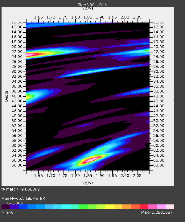
| Estimated Moho Depth: |
65.5 km |
| Estimated Crust Vp/Vs: |
1.87 |
| Assumed Crust Vp: |
6.472 km/s |
| Estimated Crust Vs: |
3.47 km/s |
| Estimated Crust Poisson's Ratio: |
0.30 |
|
| Radial Match: |
94.68892 % |
| Radial Bump: |
400 |
| Transverse Match: |
87.949 % |
| Transverse Bump: |
400 |
| SOD ConfigId: |
2669 |
| Insert Time: |
2010-03-05 19:39:04.322 +0000 |
| GWidth: |
2.5 |
| Max Bumps: |
400 |
| Tol: |
0.001 |
|
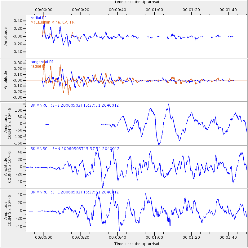
Signal To Noise
| Channel | StoN | STA | LTA |
| BK:MNRC: :BHN:20060503T15:37:51.204001Z | 0.84419125 | 6.5462933E-7 | 7.754515E-7 |
| BK:MNRC: :BHE:20060503T15:37:51.204001Z | 1.5871571 | 6.509509E-7 | 4.1013638E-7 |
| BK:MNRC: :BHZ:20060503T15:37:51.204001Z | 4.5761986 | 2.2732731E-6 | 4.9676015E-7 |
| Arrivals |
| Ps | 9.0 SECOND |
| PpPs | 28 SECOND |
| PsPs/PpSs | 37 SECOND |


