You are here: Home > Network List > BK - Berkeley Digital Seismograph Network Stations List
> Station MNRC McLaughlin Mine, CA > Earthquake Result Viewer
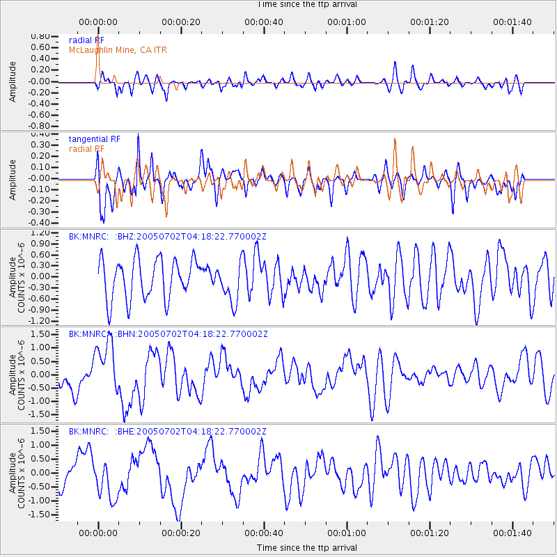
MNRC McLaughlin Mine, CA - Earthquake Result Viewer
*The percent match for this event was below the threshold and hence no stack was calculated.
| Earthquake location: |
Near Coast Of Nicaragua |
| Earthquake latitude/longitude: |
11.4/-86.3 |
| Earthquake time(UTC): |
2005/07/02 (183) 04:11:04 GMT |
| Earthquake Depth: |
40 km |
| Earthquake Magnitude: |
5.4 MB, 5.4 MS, 5.8 MW, 5.0 MD |
| Earthquake Catalog/Contributor: |
WHDF/NEIC |
|
| Network: |
BK Berkeley Digital Seismograph Network |
| Station: |
MNRC McLaughlin Mine, CA |
| Lat/Lon: |
38.88 N/122.44 W |
| Elevation: |
710 m |
|
| Distance: |
42.2 deg |
| Az: |
316.704 deg |
| Baz: |
120.519 deg |
| Ray Param: |
$rayparam |
*The percent match for this event was below the threshold and hence was not used in the summary stack. |
|
| Radial Match: |
60.211834 % |
| Radial Bump: |
400 |
| Transverse Match: |
74.363235 % |
| Transverse Bump: |
400 |
| SOD ConfigId: |
3128 |
| Insert Time: |
2010-03-05 19:39:11.379 +0000 |
| GWidth: |
2.5 |
| Max Bumps: |
400 |
| Tol: |
0.001 |
|
Signal To Noise
| Channel | StoN | STA | LTA |
| BK:MNRC: :BHN:20050702T04:18:22.770002Z | 2.3989608 | 1.0059618E-6 | 4.193323E-7 |
| BK:MNRC: :BHE:20050702T04:18:22.770002Z | 1.0366777 | 6.706784E-7 | 6.4694973E-7 |
| BK:MNRC: :BHZ:20050702T04:18:22.770002Z | 1.0411055 | 5.624798E-7 | 5.402716E-7 |
| Arrivals |
| Ps | |
| PpPs | |
| PsPs/PpSs | |


