You are here: Home > Network List > TA - USArray Transportable Network (new EarthScope stations) Stations List
> Station TUL1 Leonard, OK, USA > Earthquake Result Viewer
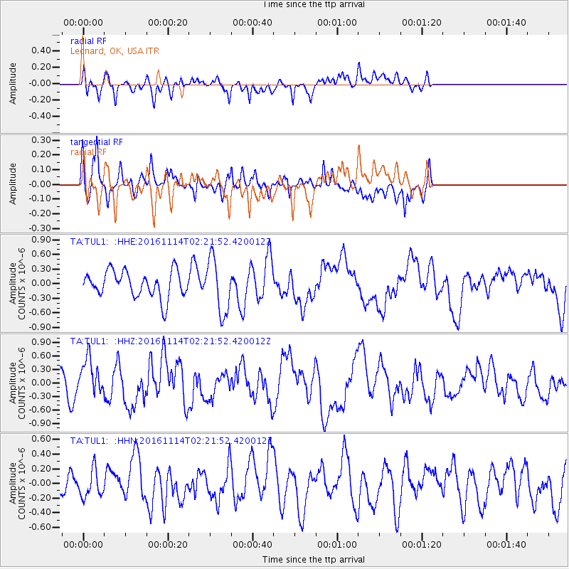
TUL1 Leonard, OK, USA - Earthquake Result Viewer
*The percent match for this event was below the threshold and hence no stack was calculated.
| Earthquake location: |
Rat Islands, Aleutian Islands |
| Earthquake latitude/longitude: |
51.1/178.8 |
| Earthquake time(UTC): |
2016/11/14 (319) 02:12:17 GMT |
| Earthquake Depth: |
34 km |
| Earthquake Magnitude: |
5.6 MWW, 5.0 ML, 5.4 ML |
| Earthquake Catalog/Contributor: |
NEIC PDE/NEIC COMCAT |
|
| Network: |
TA USArray Transportable Network (new EarthScope stations) |
| Station: |
TUL1 Leonard, OK, USA |
| Lat/Lon: |
35.91 N/95.79 W |
| Elevation: |
256 m |
|
| Distance: |
60.4 deg |
| Az: |
68.574 deg |
| Baz: |
313.662 deg |
| Ray Param: |
$rayparam |
*The percent match for this event was below the threshold and hence was not used in the summary stack. |
|
| Radial Match: |
52.553806 % |
| Radial Bump: |
400 |
| Transverse Match: |
63.59865 % |
| Transverse Bump: |
400 |
| SOD ConfigId: |
11737051 |
| Insert Time: |
2019-04-26 02:07:16.091 +0000 |
| GWidth: |
2.5 |
| Max Bumps: |
400 |
| Tol: |
0.001 |
|
Signal To Noise
| Channel | StoN | STA | LTA |
| TA:TUL1: :HHZ:20161114T02:21:52.420012Z | 1.4316866 | 4.0579144E-7 | 2.8343595E-7 |
| TA:TUL1: :HHN:20161114T02:21:52.420012Z | 0.7501564 | 1.912425E-7 | 2.5493685E-7 |
| TA:TUL1: :HHE:20161114T02:21:52.420012Z | 2.1637752 | 5.748504E-7 | 2.656701E-7 |
| Arrivals |
| Ps | |
| PpPs | |
| PsPs/PpSs | |


