You are here: Home > Network List > TJ - Tajikistan National Seismic Network Stations List
> Station GARM Garm, Tajikistan > Earthquake Result Viewer
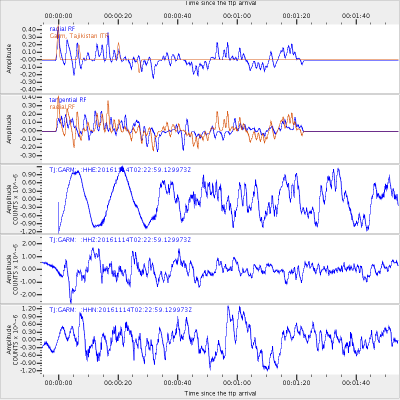
GARM Garm, Tajikistan - Earthquake Result Viewer
*The percent match for this event was below the threshold and hence no stack was calculated.
| Earthquake location: |
Rat Islands, Aleutian Islands |
| Earthquake latitude/longitude: |
51.1/178.8 |
| Earthquake time(UTC): |
2016/11/14 (319) 02:12:17 GMT |
| Earthquake Depth: |
34 km |
| Earthquake Magnitude: |
5.6 MWW, 5.0 ML, 5.4 ML |
| Earthquake Catalog/Contributor: |
NEIC PDE/NEIC COMCAT |
|
| Network: |
TJ Tajikistan National Seismic Network |
| Station: |
GARM Garm, Tajikistan |
| Lat/Lon: |
39.00 N/70.32 E |
| Elevation: |
1305 m |
|
| Distance: |
70.7 deg |
| Az: |
308.49 deg |
| Baz: |
39.325 deg |
| Ray Param: |
$rayparam |
*The percent match for this event was below the threshold and hence was not used in the summary stack. |
|
| Radial Match: |
77.27789 % |
| Radial Bump: |
400 |
| Transverse Match: |
39.465435 % |
| Transverse Bump: |
400 |
| SOD ConfigId: |
11737051 |
| Insert Time: |
2019-04-26 02:07:24.890 +0000 |
| GWidth: |
2.5 |
| Max Bumps: |
400 |
| Tol: |
0.001 |
|
Signal To Noise
| Channel | StoN | STA | LTA |
| TJ:GARM: :HHZ:20161114T02:22:59.129973Z | 4.614631 | 1.0151804E-6 | 2.1999165E-7 |
| TJ:GARM: :HHN:20161114T02:22:59.129973Z | 1.0770262 | 3.53302E-7 | 3.2803473E-7 |
| TJ:GARM: :HHE:20161114T02:22:59.129973Z | 1.0860747 | 8.0269837E-7 | 7.390821E-7 |
| Arrivals |
| Ps | |
| PpPs | |
| PsPs/PpSs | |


