You are here: Home > Network List > BK - Berkeley Digital Seismograph Network Stations List
> Station MOD Modoc Plateau, CA > Earthquake Result Viewer
MOD Modoc Plateau, CA - Earthquake Result Viewer
| Earthquake location: |
South Of Fiji Islands |
| Earthquake latitude/longitude: |
-26.9/-176.3 |
| Earthquake time(UTC): |
2005/06/28 (179) 15:46:25 GMT |
| Earthquake Depth: |
31 km |
| Earthquake Magnitude: |
5.4 MB, 5.6 MS, 5.8 MW |
| Earthquake Catalog/Contributor: |
WHDF/NEIC |
|
| Network: |
BK Berkeley Digital Seismograph Network |
| Station: |
MOD Modoc Plateau, CA |
| Lat/Lon: |
41.90 N/120.30 W |
| Elevation: |
1554 m |
|
| Distance: |
85.8 deg |
| Az: |
38.348 deg |
| Baz: |
227.904 deg |
| Ray Param: |
0.044461466 |
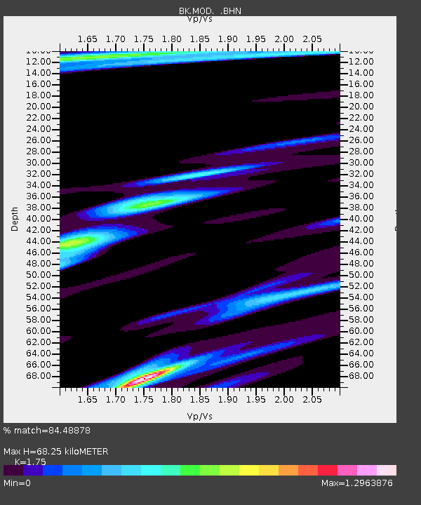
| Estimated Moho Depth: |
68.25 km |
| Estimated Crust Vp/Vs: |
1.75 |
| Assumed Crust Vp: |
6.566 km/s |
| Estimated Crust Vs: |
3.752 km/s |
| Estimated Crust Poisson's Ratio: |
0.26 |
|
| Radial Match: |
84.48878 % |
| Radial Bump: |
400 |
| Transverse Match: |
63.35308 % |
| Transverse Bump: |
400 |
| SOD ConfigId: |
124340 |
| Insert Time: |
2010-03-05 19:39:16.685 +0000 |
| GWidth: |
2.5 |
| Max Bumps: |
400 |
| Tol: |
0.001 |
|
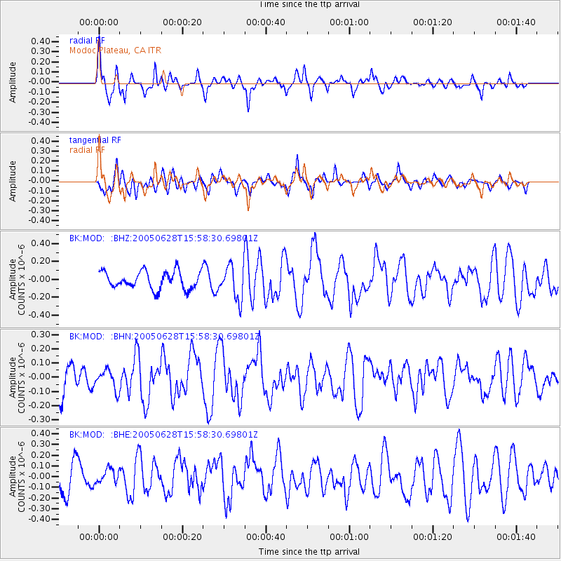
Signal To Noise
| Channel | StoN | STA | LTA |
| BK:MOD: :BHN:20050628T15:58:30.69801Z | 0.6008362 | 7.073447E-8 | 1.1772671E-7 |
| BK:MOD: :BHE:20050628T15:58:30.69801Z | 0.6797016 | 7.646601E-8 | 1.1249938E-7 |
| BK:MOD: :BHZ:20050628T15:58:30.69801Z | 2.041372 | 1.9815869E-7 | 9.707133E-8 |
| Arrivals |
| Ps | 8.0 SECOND |
| PpPs | 28 SECOND |
| PsPs/PpSs | 36 SECOND |


