You are here: Home > Network List > BK - Berkeley Digital Seismograph Network Stations List
> Station MOD Modoc Plateau, CA > Earthquake Result Viewer
MOD Modoc Plateau, CA - Earthquake Result Viewer
| Earthquake location: |
Easter Island Region |
| Earthquake latitude/longitude: |
-23.9/-112.0 |
| Earthquake time(UTC): |
2005/06/19 (170) 02:01:06 GMT |
| Earthquake Depth: |
10 km |
| Earthquake Magnitude: |
5.6 MB, 5.3 MS, 5.7 MW, 5.7 MW |
| Earthquake Catalog/Contributor: |
WHDF/NEIC |
|
| Network: |
BK Berkeley Digital Seismograph Network |
| Station: |
MOD Modoc Plateau, CA |
| Lat/Lon: |
41.90 N/120.30 W |
| Elevation: |
1554 m |
|
| Distance: |
66.0 deg |
| Az: |
353.208 deg |
| Baz: |
171.666 deg |
| Ray Param: |
0.057922866 |
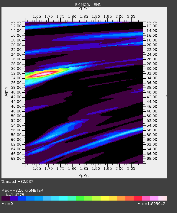
| Estimated Moho Depth: |
32.0 km |
| Estimated Crust Vp/Vs: |
1.68 |
| Assumed Crust Vp: |
6.566 km/s |
| Estimated Crust Vs: |
3.914 km/s |
| Estimated Crust Poisson's Ratio: |
0.22 |
|
| Radial Match: |
82.937 % |
| Radial Bump: |
281 |
| Transverse Match: |
43.98522 % |
| Transverse Bump: |
389 |
| SOD ConfigId: |
124340 |
| Insert Time: |
2010-03-05 19:39:18.896 +0000 |
| GWidth: |
2.5 |
| Max Bumps: |
400 |
| Tol: |
0.001 |
|
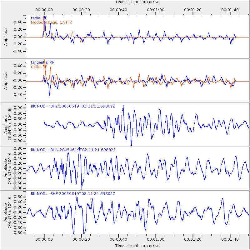
Signal To Noise
| Channel | StoN | STA | LTA |
| BK:MOD: :BHN:20050619T02:11:21.69802Z | 1.8890762 | 1.3111246E-7 | 6.9405594E-8 |
| BK:MOD: :BHE:20050619T02:11:21.69802Z | 0.9374404 | 1.5472796E-7 | 1.6505365E-7 |
| BK:MOD: :BHZ:20050619T02:11:21.69802Z | 2.0514812 | 2.1374656E-7 | 1.0419133E-7 |
| Arrivals |
| Ps | 3.5 SECOND |
| PpPs | 12 SECOND |
| PsPs/PpSs | 16 SECOND |


