You are here: Home > Network List > BK - Berkeley Digital Seismograph Network Stations List
> Station MOD Modoc Plateau, CA > Earthquake Result Viewer
MOD Modoc Plateau, CA - Earthquake Result Viewer
| Earthquake location: |
Mariana Islands |
| Earthquake latitude/longitude: |
16.0/145.9 |
| Earthquake time(UTC): |
2005/02/05 (036) 03:34:25 GMT |
| Earthquake Depth: |
143 km |
| Earthquake Magnitude: |
6.3 MB, 6.6 MW, 6.5 MW |
| Earthquake Catalog/Contributor: |
WHDF/NEIC |
|
| Network: |
BK Berkeley Digital Seismograph Network |
| Station: |
MOD Modoc Plateau, CA |
| Lat/Lon: |
41.90 N/120.30 W |
| Elevation: |
1554 m |
|
| Distance: |
82.3 deg |
| Az: |
48.735 deg |
| Baz: |
284.456 deg |
| Ray Param: |
0.046672083 |
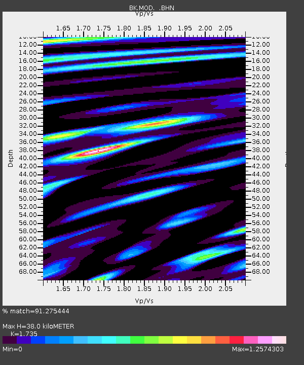
| Estimated Moho Depth: |
38.0 km |
| Estimated Crust Vp/Vs: |
1.74 |
| Assumed Crust Vp: |
6.566 km/s |
| Estimated Crust Vs: |
3.785 km/s |
| Estimated Crust Poisson's Ratio: |
0.25 |
|
| Radial Match: |
91.275444 % |
| Radial Bump: |
400 |
| Transverse Match: |
84.95163 % |
| Transverse Bump: |
400 |
| SOD ConfigId: |
5233 |
| Insert Time: |
2010-03-05 19:39:32.970 +0000 |
| GWidth: |
2.5 |
| Max Bumps: |
400 |
| Tol: |
0.001 |
|
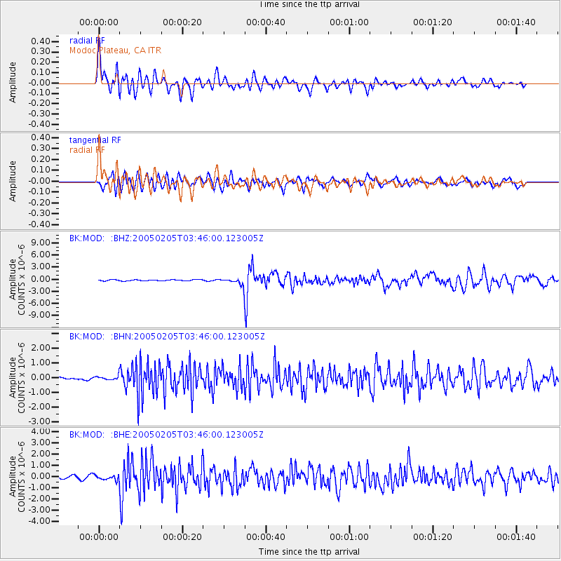
Signal To Noise
| Channel | StoN | STA | LTA |
| BK:MOD: :BHN:20050205T03:46:00.123005Z | 1.5040834 | 1.4643788E-7 | 9.736022E-8 |
| BK:MOD: :BHE:20050205T03:46:00.123005Z | 1.8244921 | 2.0321716E-7 | 1.1138286E-7 |
| BK:MOD: :BHZ:20050205T03:46:00.123005Z | 6.681829 | 9.23013E-7 | 1.3813776E-7 |
| Arrivals |
| Ps | 4.4 SECOND |
| PpPs | 15 SECOND |
| PsPs/PpSs | 20 SECOND |


