You are here: Home > Network List > BK - Berkeley Digital Seismograph Network Stations List
> Station MOD Modoc Plateau, CA > Earthquake Result Viewer
MOD Modoc Plateau, CA - Earthquake Result Viewer
| Earthquake location: |
Mariana Islands |
| Earthquake latitude/longitude: |
20.1/145.8 |
| Earthquake time(UTC): |
2005/08/13 (225) 07:36:52 GMT |
| Earthquake Depth: |
49 km |
| Earthquake Magnitude: |
5.8 MB, 5.6 MS, 6.0 MW, 6.0 MW |
| Earthquake Catalog/Contributor: |
WHDF/NEIC |
|
| Network: |
BK Berkeley Digital Seismograph Network |
| Station: |
MOD Modoc Plateau, CA |
| Lat/Lon: |
41.90 N/120.30 W |
| Elevation: |
1554 m |
|
| Distance: |
79.6 deg |
| Az: |
49.214 deg |
| Baz: |
287.63 deg |
| Ray Param: |
0.04874417 |
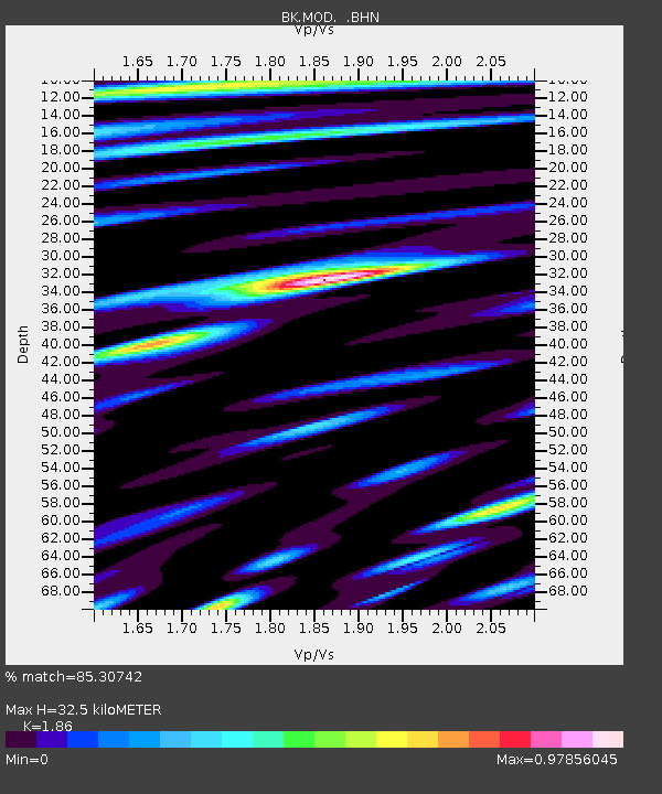
| Estimated Moho Depth: |
32.5 km |
| Estimated Crust Vp/Vs: |
1.86 |
| Assumed Crust Vp: |
6.566 km/s |
| Estimated Crust Vs: |
3.53 km/s |
| Estimated Crust Poisson's Ratio: |
0.30 |
|
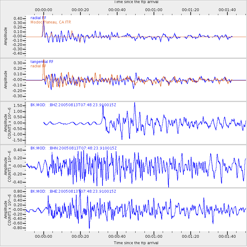
| Radial Match: |
85.30742 % |
| Radial Bump: |
400 |
| Transverse Match: |
73.15102 % |
| Transverse Bump: |
400 |
| SOD ConfigId: |
2422 |
| Insert Time: |
2010-03-05 19:39:38.968 +0000 |
| GWidth: |
2.5 |
| Max Bumps: |
400 |
| Tol: |
0.001 |
|
Signal To Noise
| Channel | StoN | STA | LTA |
| BK:MOD: :BHN:20050813T07:48:23.910015Z | 1.6149464 | 1.3591841E-7 | 8.41628E-8 |
| BK:MOD: :BHE:20050813T07:48:23.910015Z | 3.4725127 | 1.7832647E-7 | 5.1353727E-8 |
| BK:MOD: :BHZ:20050813T07:48:23.910015Z | 7.6725903 | 5.1973694E-7 | 6.7739435E-8 |
| Arrivals |
| Ps | 4.4 SECOND |
| PpPs | 14 SECOND |
| PsPs/PpSs | 18 SECOND |


