You are here: Home > Network List > BK - Berkeley Digital Seismograph Network Stations List
> Station MOD Modoc Plateau, CA > Earthquake Result Viewer
MOD Modoc Plateau, CA - Earthquake Result Viewer
| Earthquake location: |
Vanuatu Islands Region |
| Earthquake latitude/longitude: |
-20.9/173.8 |
| Earthquake time(UTC): |
2005/08/09 (221) 05:26:17 GMT |
| Earthquake Depth: |
24 km |
| Earthquake Magnitude: |
5.5 MB, 6.0 MS, 6.1 MW, 6.1 MW |
| Earthquake Catalog/Contributor: |
WHDF/NEIC |
|
| Network: |
BK Berkeley Digital Seismograph Network |
| Station: |
MOD Modoc Plateau, CA |
| Lat/Lon: |
41.90 N/120.30 W |
| Elevation: |
1554 m |
|
| Distance: |
87.2 deg |
| Az: |
43.008 deg |
| Baz: |
238.66 deg |
| Ray Param: |
0.043468717 |
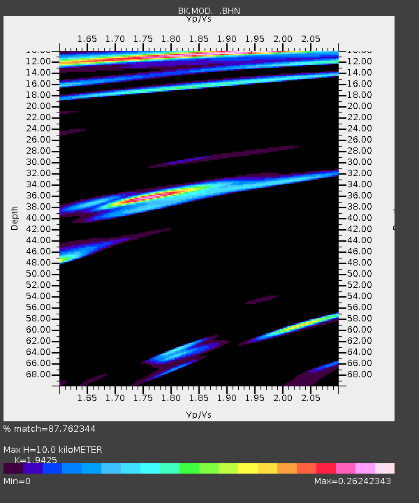
| Estimated Moho Depth: |
10.0 km |
| Estimated Crust Vp/Vs: |
1.94 |
| Assumed Crust Vp: |
6.566 km/s |
| Estimated Crust Vs: |
3.38 km/s |
| Estimated Crust Poisson's Ratio: |
0.32 |
|
| Radial Match: |
87.762344 % |
| Radial Bump: |
400 |
| Transverse Match: |
58.834217 % |
| Transverse Bump: |
400 |
| SOD ConfigId: |
2422 |
| Insert Time: |
2010-03-05 19:39:41.355 +0000 |
| GWidth: |
2.5 |
| Max Bumps: |
400 |
| Tol: |
0.001 |
|
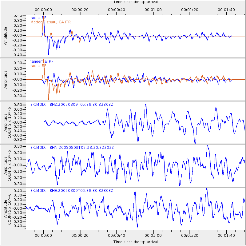
Signal To Noise
| Channel | StoN | STA | LTA |
| BK:MOD: :BHN:20050809T05:38:30.32303Z | 0.71886575 | 4.8640302E-8 | 6.766257E-8 |
| BK:MOD: :BHE:20050809T05:38:30.32303Z | 0.85497725 | 5.246532E-8 | 6.136458E-8 |
| BK:MOD: :BHZ:20050809T05:38:30.32303Z | 2.902096 | 1.7532611E-7 | 6.041361E-8 |
| Arrivals |
| Ps | 1.5 SECOND |
| PpPs | 4.4 SECOND |
| PsPs/PpSs | 5.9 SECOND |


