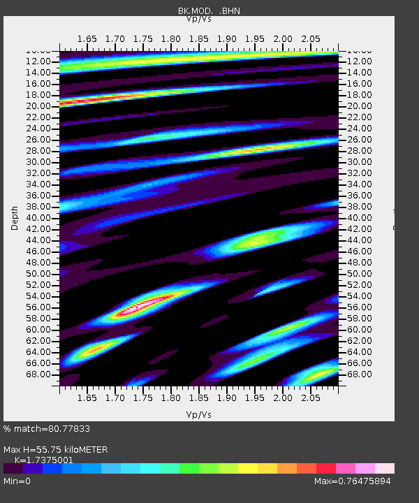
MOD Modoc Plateau, CA - Earthquake Result Viewer
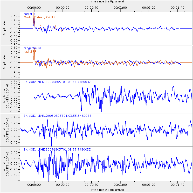
Earthquake location: Andreanof Islands, Aleutian Is.
Earthquake latitude/longitude: 51.2/-178.3
Earthquake time(UTC): 2005/08/05 (217) 00:56:53 GMT
Earthquake Depth: 23 km
Earthquake Magnitude: 5.6 MB, 5.3 MS, 5.8 MW, 5.7 MW
Earthquake Catalog/Contributor: WHDF/NEIC
Network: BK Berkeley Digital Seismograph Network
Station: MOD Modoc Plateau, CA
Lat/Lon: 41.90 N/120.30 W
Elevation: 1554 m
Distance: 40.0 deg
Az: 80.115 deg
Baz: 303.936 deg
Ray Param: 0.074637115
Estimated Moho Depth: 55.75 km
Estimated Crust Vp/Vs: 1.74
Assumed Crust Vp: 6.566 km/s
Estimated Crust Vs: 3.779 km/s
Estimated Crust Poisson's Ratio: 0.25
Radial Match: 80.77833 %
Radial Bump: 400
Transverse Match: 64.7478 %
Transverse Bump: 400
SOD ConfigId: 2422
Insert Time: 2010-03-05 19:39:42.786 +0000
GWidth: 2.5
Max Bumps: 400
Tol: 0.001

Signal To Noise

ChannelStoNSTALTA
BK:MOD: :BHN:20050805T01:03:55.548003Z1.44581828.7586045E-86.057888E-8
BK:MOD: :BHE:20050805T01:03:55.548003Z2.5167341.5880758E-76.3100664E-8
BK:MOD: :BHZ:20050805T01:03:55.548003Z3.09349732.3274534E-77.523696E-8
Arrivals
Ps6.8 SECOND
PpPs22 SECOND
PsPs/PpSs28 SECOND