You are here: Home > Network List > BK - Berkeley Digital Seismograph Network Stations List
> Station MOD Modoc Plateau, CA > Earthquake Result Viewer
MOD Modoc Plateau, CA - Earthquake Result Viewer
| Earthquake location: |
Kuril Islands |
| Earthquake latitude/longitude: |
47.0/153.9 |
| Earthquake time(UTC): |
2005/08/01 (213) 04:40:36 GMT |
| Earthquake Depth: |
17 km |
| Earthquake Magnitude: |
5.4 MB, 5.1 MS, 5.7 MW, 5.7 MW |
| Earthquake Catalog/Contributor: |
WHDF/NEIC |
|
| Network: |
BK Berkeley Digital Seismograph Network |
| Station: |
MOD Modoc Plateau, CA |
| Lat/Lon: |
41.90 N/120.30 W |
| Elevation: |
1554 m |
|
| Distance: |
58.5 deg |
| Az: |
60.836 deg |
| Baz: |
306.802 deg |
| Ray Param: |
0.062793046 |
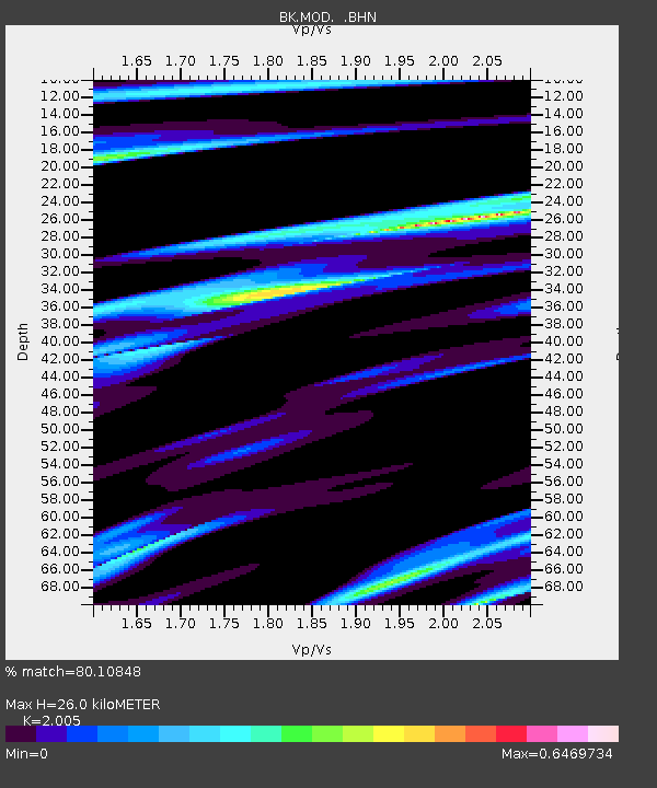
| Estimated Moho Depth: |
26.0 km |
| Estimated Crust Vp/Vs: |
2.01 |
| Assumed Crust Vp: |
6.566 km/s |
| Estimated Crust Vs: |
3.275 km/s |
| Estimated Crust Poisson's Ratio: |
0.33 |
|
| Radial Match: |
80.10848 % |
| Radial Bump: |
395 |
| Transverse Match: |
55.334595 % |
| Transverse Bump: |
400 |
| SOD ConfigId: |
2422 |
| Insert Time: |
2010-03-05 19:39:44.198 +0000 |
| GWidth: |
2.5 |
| Max Bumps: |
400 |
| Tol: |
0.001 |
|
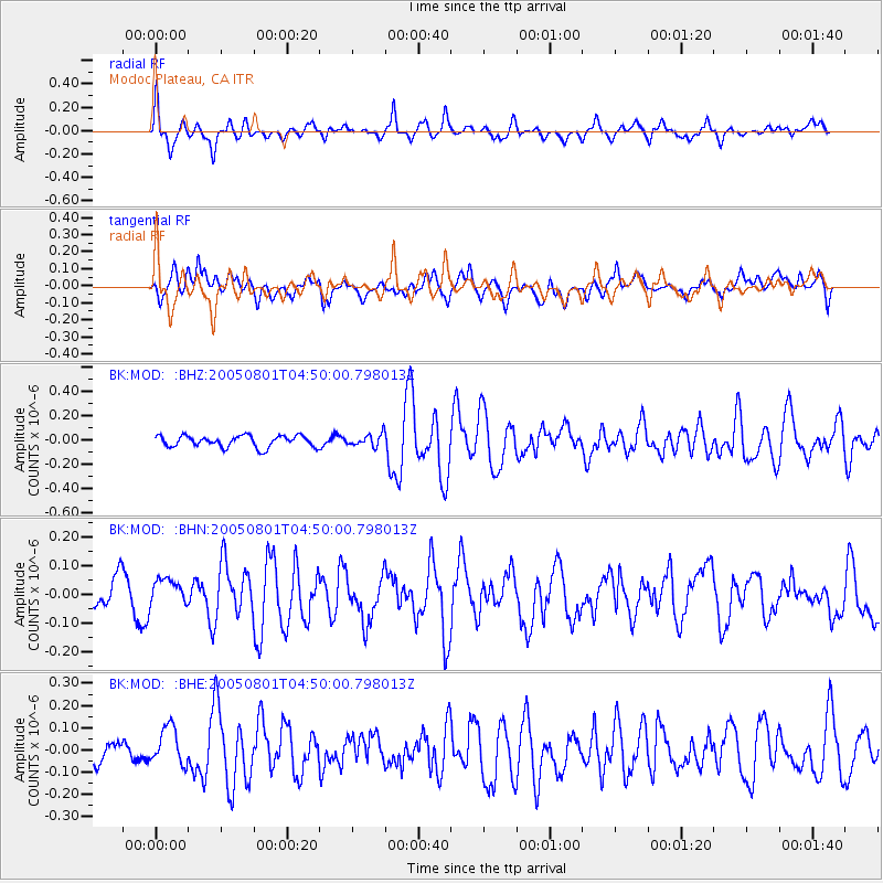
Signal To Noise
| Channel | StoN | STA | LTA |
| BK:MOD: :BHN:20050801T04:50:00.798013Z | 0.90192217 | 6.539026E-8 | 7.2501E-8 |
| BK:MOD: :BHE:20050801T04:50:00.798013Z | 1.4630647 | 8.525412E-8 | 5.827092E-8 |
| BK:MOD: :BHZ:20050801T04:50:00.798013Z | 1.0623914 | 4.987034E-8 | 4.694159E-8 |
| Arrivals |
| Ps | 4.2 SECOND |
| PpPs | 11 SECOND |
| PsPs/PpSs | 16 SECOND |


