You are here: Home > Network List > BK - Berkeley Digital Seismograph Network Stations List
> Station MOD Modoc Plateau, CA > Earthquake Result Viewer
MOD Modoc Plateau, CA - Earthquake Result Viewer
| Earthquake location: |
Solomon Islands |
| Earthquake latitude/longitude: |
-7.7/159.5 |
| Earthquake time(UTC): |
2005/01/22 (022) 20:30:17 GMT |
| Earthquake Depth: |
29 km |
| Earthquake Magnitude: |
6.2 MB, 6.5 MS, 6.4 MW, 6.4 MW |
| Earthquake Catalog/Contributor: |
WHDF/NEIC |
|
| Network: |
BK Berkeley Digital Seismograph Network |
| Station: |
MOD Modoc Plateau, CA |
| Lat/Lon: |
41.90 N/120.30 W |
| Elevation: |
1554 m |
|
| Distance: |
87.9 deg |
| Az: |
47.405 deg |
| Baz: |
257.77 deg |
| Ray Param: |
0.04295699 |
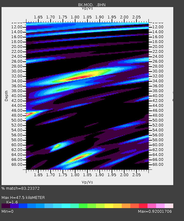
| Estimated Moho Depth: |
47.5 km |
| Estimated Crust Vp/Vs: |
1.60 |
| Assumed Crust Vp: |
6.566 km/s |
| Estimated Crust Vs: |
4.104 km/s |
| Estimated Crust Poisson's Ratio: |
0.18 |
|
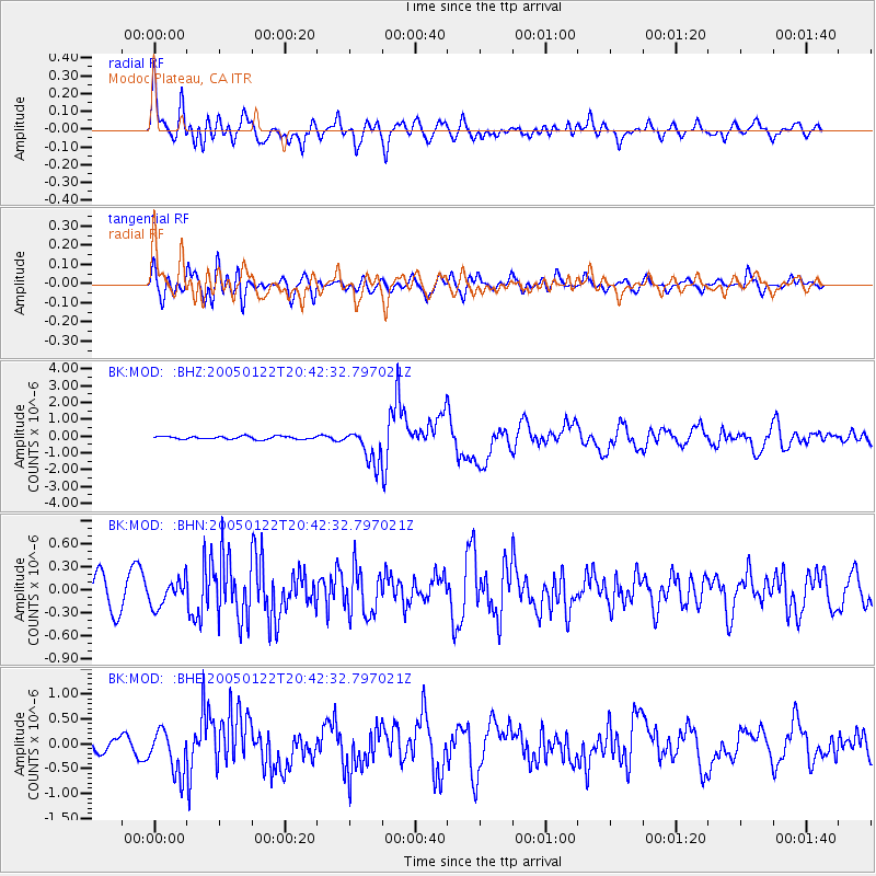
| Radial Match: |
83.23372 % |
| Radial Bump: |
400 |
| Transverse Match: |
72.408516 % |
| Transverse Bump: |
400 |
| SOD ConfigId: |
5233 |
| Insert Time: |
2010-03-05 19:39:47.368 +0000 |
| GWidth: |
2.5 |
| Max Bumps: |
400 |
| Tol: |
0.001 |
|
Signal To Noise
| Channel | StoN | STA | LTA |
| BK:MOD: :BHN:20050122T20:42:32.797021Z | 1.0444007 | 1.7274323E-7 | 1.6539938E-7 |
| BK:MOD: :BHE:20050122T20:42:32.797021Z | 2.71077 | 4.349474E-7 | 1.604516E-7 |
| BK:MOD: :BHZ:20050122T20:42:32.797021Z | 11.291183 | 1.0108788E-6 | 8.952816E-8 |
| Arrivals |
| Ps | 4.5 SECOND |
| PpPs | 18 SECOND |
| PsPs/PpSs | 23 SECOND |


